1930s Maps of Gunnings, Kingsport
Explore 3 historic maps of Gunnings from the 1930s. These maps offer a rare glimpse into what life looked like during the 1930s — showing old roads, neighborhoods, homes, and landmarks that have changed or disappeared over time.
Whether you're researching your family's past, planning a metal detecting trip, or studying how Gunnings's landscape evolved across the 1930s, these high-resolution maps are a powerful tool for exploring the history of this region.
- Focus on a specific era: All maps on this page are from the 1930s, giving you a focused view of this time period.
- See what’s changed: Compare century-old streets, trails, and buildings to today's modern landscape using overlays and satellite layers.
- Research with precision: Use these maps for genealogy, historical research, land use analysis, or educational projects.
- View, download, or print: Maps are fully viewable online in high resolution, and can be downloaded or printed for your own records.
Start exploring Gunnings's history through authentic maps from the 1930s. This is your window into the past.
Gunnings, Kingsport maps
(3)- 1935 Map of Indian Springs
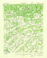 1935 Indian Springs1935 Print · USGSSullivan County and the Virginia borderlands are captured here in the mid-1930s as modern power and aviation networks began to reach these rural communities. Genealogists can locate family landmarks like Pyles Cem, Huddle Mill, and numerous neighborhood schools including Shadylawn Sch.
 - 1935 Map of Mages
 1935 Mages1935 Print · USGSThe Tennessee-Virginia borderlands appear here in the mid-1930s, showing a landscape of ridge-and-valley settlements and rural crossroads. Researchers can locate numerous family-centered sites including Pyles Cem, St Joseph Ch, and Mill Point.
 - 1939 Map of Indian Springs, 1954 Print
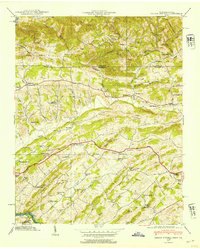 1939 Indian Springs1954 Print · USGSSullivan County, Tennessee, and Scott County, Virginia, are captured here at the end of the 1930s as a network of creek-side farms and mountain gaps. Genealogists can locate family landmarks like Pyles Cem, Bridwell Town, and schools like Gunnings Academy or Shadylawn Sch.
End of results
Showing maps 1-3 of 3
Top cities near Gunnings
- Johnson City historical maps
- Kingsport historical maps
- Bristol historical maps
- Bristol historical maps
- Elizabethton historical maps
- Bloomingdale historical maps
See more
Frequently asked questions
- What are the different types of historical maps available for Gunnings?
- What is the oldest map of Gunnings?
- Where can I purchase historical maps of Gunnings for my home or office?
- Where can I download high-res historical maps of Gunnings?
- Are there historical topographic maps available for Gunnings?
- Is there historical aerial imagery available for Gunnings?
- Where are historical maps of Gunnings sourced from?