1970s Maps of Garland, Tennessee
Explore 4 historic maps of Garland from the 1970s. These maps offer a rare glimpse into what life looked like during the 1970s — showing old roads, neighborhoods, homes, and landmarks that have changed or disappeared over time.
Whether you're researching your family's past, planning a metal detecting trip, or studying how Garland's landscape evolved across the 1970s, these high-resolution maps are a powerful tool for exploring the history of this region.
- Focus on a specific era: All maps on this page are from the 1970s, giving you a focused view of this time period.
- See what’s changed: Compare century-old streets, trails, and buildings to today's modern landscape using overlays and satellite layers.
- Research with precision: Use these maps for genealogy, historical research, land use analysis, or educational projects.
- View, download, or print: Maps are fully viewable online in high resolution, and can be downloaded or printed for your own records.
Start exploring Garland's history through authentic maps from the 1970s. This is your window into the past.
Garland, TN maps
(4)- 1972 Map of Covington, 1974 Print
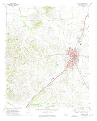 1972 Covington1974 Print · USGSCovington and rural Tipton County are captured here in the early seventies as the town expanded along the Illinois Central Gulf rail line. Researchers can trace local heritage through the sites of Mount Lebanon, Shiloh Cem, and the Drive-in Theater.2 unique versions available
 - 1972 Map of Gilt Edge, 1974 Print
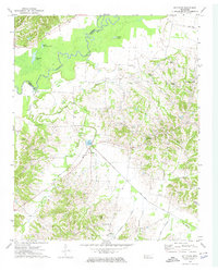 1972 Gilt Edge1974 Print · USGSThe rural communities of Tipton and Lauderdale Counties come into focus in the early 1970s, bounded by the winding Hatchie River. Researchers can trace family roots through numerous local landmarks, including Smyrna Cem, Gilt Edge, and Kelley Chapel.2 unique versions available
 - 1977 Map of Rialto
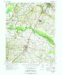 1977 Rialto1977 Print · USGSTipton and Lauderdale counties are documented here in the late seventies, showing the traditional river-and-rail corridor along the Hatchie River. Genealogists can trace family landmarks across dozens of sites, including Leighs Chapel, Pilgrims Rest Cem, and the Henning Sch.
 - 1977 Map of Osceola
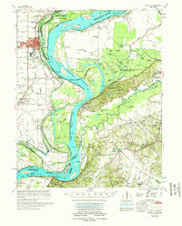 1977 Osceola1977 Print · USGSThe Mississippi Delta's winding riverborder comes alive in the 1970s, showing the complex interaction of the Mississippi River and the riverfront communities. Genealogists and local historians can locate many rural landmarks, from Nodena Cem and Mississippi County Memorial Gardens to the river-bluff heights of Fort Pillow State Park.
End of results
Showing maps 1-4 of 4
Top cities near Garland
- Millington historical maps
- Covington historical maps
- Osceola historical maps
- Ripley historical maps
- Atoka historical maps
- Munford historical maps
See more
Frequently asked questions
- What are the different types of historical maps available for Garland?
- What is the oldest map of Garland?
- Where can I purchase historical maps of Garland for my home or office?
- Where can I download high-res historical maps of Garland?
- Are there historical topographic maps available for Garland?
- Is there historical aerial imagery available for Garland?
- Where are historical maps of Garland sourced from?