1930s Maps of Pleasant Garden, Tennessee
Explore 2 historic maps of Pleasant Garden from the 1930s. These maps offer a rare glimpse into what life looked like during the 1930s — showing old roads, neighborhoods, homes, and landmarks that have changed or disappeared over time.
Whether you're researching your family's past, planning a metal detecting trip, or studying how Pleasant Garden's landscape evolved across the 1930s, these high-resolution maps are a powerful tool for exploring the history of this region.
- Focus on a specific era: All maps on this page are from the 1930s, giving you a focused view of this time period.
- See what’s changed: Compare century-old streets, trails, and buildings to today's modern landscape using overlays and satellite layers.
- Research with precision: Use these maps for genealogy, historical research, land use analysis, or educational projects.
- View, download, or print: Maps are fully viewable online in high resolution, and can be downloaded or printed for your own records.
Start exploring Pleasant Garden's history through authentic maps from the 1930s. This is your window into the past.
Pleasant Garden, TN maps
(2)- 1935 Map of Unicoi
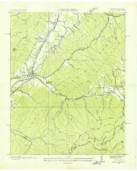 1935 Unicoi1935 Print · USGSThe Unicoi area in the mid-1930s reveals a mountain landscape of tight-knit valley settlements and extensive national forest trails. Researchers can trace the legacy of the Clinchfield and Ohio RR, the CCC Camp Cordell Hull, and family-named sites like Jones Chapel and Swingle Cem.
 - 1939 Map of Unicoi
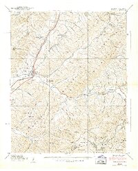 1939 Unicoi1939 Print · USGSThe Unicoi area at the start of the 1940s is a rugged landscape of rail-connected valleys and high mountain gaps. Genealogists and hikers can trace the original Appalachian Trail through Low Gap or locate family sites like Peterson Cem and CCC Camp Cordell Hull.4 unique versions available
End of results
Showing maps 1-2 of 2
Top cities near Pleasant Garden
- Johnson City historical maps
- Elizabethton historical maps
- Erwin historical maps
- Jonesborough historical maps
- Unicoi historical maps
- Pine Crest historical maps
See more
Frequently asked questions
- What are the different types of historical maps available for Pleasant Garden?
- What is the oldest map of Pleasant Garden?
- Where can I purchase historical maps of Pleasant Garden for my home or office?
- Where can I download high-res historical maps of Pleasant Garden?
- Are there historical topographic maps available for Pleasant Garden?
- Is there historical aerial imagery available for Pleasant Garden?
- Where are historical maps of Pleasant Garden sourced from?