1950s Maps of Maynardville, Tennessee
Explore 4 historic maps of Maynardville from the 1950s. These maps offer a rare glimpse into what life looked like during the 1950s — showing old roads, neighborhoods, homes, and landmarks that have changed or disappeared over time.
Whether you're researching your family's past, planning a metal detecting trip, or studying how Maynardville's landscape evolved across the 1950s, these high-resolution maps are a powerful tool for exploring the history of this region.
- Focus on a specific era: All maps on this page are from the 1950s, giving you a focused view of this time period.
- See what’s changed: Compare century-old streets, trails, and buildings to today's modern landscape using overlays and satellite layers.
- Research with precision: Use these maps for genealogy, historical research, land use analysis, or educational projects.
- View, download, or print: Maps are fully viewable online in high resolution, and can be downloaded or printed for your own records.
Start exploring Maynardville's history through authentic maps from the 1950s. This is your window into the past.
Maynardville, TN maps
(4)- 1952 Map of Maynardville, 1954 Print
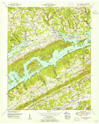 1952 Maynardville1954 Print · USGSMaynardville and the surrounding Tennessee valleys are captured here during the early 1950s, a time when the landscape was adapting to the creation of NORRIS LAKE. Genealogists and historians can trace family roots through numerous sites like the Berry-Peters Mill, Ellisons Store, and the Pleasant View Church.3 unique versions available
 - 1952 Map of Graveston, 1954 Print
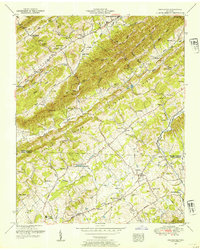 1952 Graveston1954 Print · USGSUnion and Knox Counties are shown in the early fifties as the rural landscape of East Tennessee maintained its tight-knit network of ridge-side farms and rail-line towns. Genealogists can trace family names across dozens of sites like the Alder Springs Cemetery, Bullrun School, and the community of Corryton.4 unique versions available
 - 1955 Map of Johnson City
 1955 Johnson City1955 Print · USGSEast Tennessee and the bordering highlands of Virginia and Kentucky appear here during the post-war industrial boom. You can trace the complex network of mountain ridges and new TVA lakes, from Johnson City to the coalfields near Middlesboro and Lynch.
 - 1957 Map of Johnson City, 1966 Print
 1957 Johnson City1966 Print · USGSUpper East Tennessee and Southwest Virginia are shown here during the mid-sixties transition of the Appalachians. Researchers can trace the industrial rail hubs of Kingsport, the sprawling waters of Cherokee Lake, and the historic Cumberland Gap.
End of results
Showing maps 1-4 of 4
Top cities near Maynardville
- Knoxville historical maps
- Powell historical maps
- Halls Crossroads historical maps
- New Tazewell historical maps
- Mascot historical maps
- Strawberry Plains historical maps
See more
Top neighborhoods of Maynardville
Frequently asked questions
- What are the different types of historical maps available for Maynardville?
- What is the oldest map of Maynardville?
- Where can I purchase historical maps of Maynardville for my home or office?
- Where can I download high-res historical maps of Maynardville?
- Are there historical topographic maps available for Maynardville?
- Is there historical aerial imagery available for Maynardville?
- Where are historical maps of Maynardville sourced from?