1930s Maps of Maynardville, Tennessee
Explore 4 historic maps of Maynardville from the 1930s. These maps offer a rare glimpse into what life looked like during the 1930s — showing old roads, neighborhoods, homes, and landmarks that have changed or disappeared over time.
Whether you're researching your family's past, planning a metal detecting trip, or studying how Maynardville's landscape evolved across the 1930s, these high-resolution maps are a powerful tool for exploring the history of this region.
- Focus on a specific era: All maps on this page are from the 1930s, giving you a focused view of this time period.
- See what’s changed: Compare century-old streets, trails, and buildings to today's modern landscape using overlays and satellite layers.
- Research with precision: Use these maps for genealogy, historical research, land use analysis, or educational projects.
- View, download, or print: Maps are fully viewable online in high resolution, and can be downloaded or printed for your own records.
Start exploring Maynardville's history through authentic maps from the 1930s. This is your window into the past.
Maynardville, TN maps
(4)- 1935 Map of Graveston
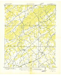 1935 Graveston1935 Print · USGSEastern Tennessee in the mid-1930s was a landscape of small schools and valley settlements centered around Maynardville and Corryton. Genealogists and historians can trace family roots through landmarks like Millers Chapel, the Graveston Mill Pond, and Plain View Sch.
 - 1936 Map of Gorryton
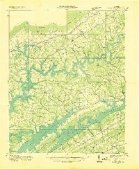
 1936 Gorryton1936 Print · USGSNortheast of Knoxville in the mid-1930s, the landscape was being reshaped by the newly flooded Norris Reservoir. Genealogists and historians can trace numerous rural landmarks, including Welch Mill, Big Ridge Park Cemetery, and the Southern Railway corridor.
 - 1936 Map of Mc Lean Rock
 1936 Mc Lean Rock1936 Print · USGSUnion and Claiborne counties appear just as the Tennessee Valley Authority was reshaping the land in the mid-1930s. Researchers can locate family roots at Rose Hill Ch & Cem, trace the early operations of Lead Mine, or find the historic Speedwell Academy.
 - 1936 Map of Maynardville
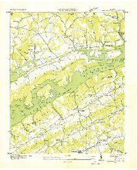 1936 Maynardville1936 Print · USGSIn the mid-1930s, the rising waters of Norris Reservoir began reshaping Union County. Genealogists and local historians can trace family land and community landmarks like Berry Peter Mill, Lickskillet, and Big Barren Cem.
End of results
Showing maps 1-4 of 4
Top cities near Maynardville
- Knoxville historical maps
- Powell historical maps
- Halls Crossroads historical maps
- New Tazewell historical maps
- Mascot historical maps
- Strawberry Plains historical maps
See more
Top neighborhoods of Maynardville
Frequently asked questions
- What are the different types of historical maps available for Maynardville?
- What is the oldest map of Maynardville?
- Where can I purchase historical maps of Maynardville for my home or office?
- Where can I download high-res historical maps of Maynardville?
- Are there historical topographic maps available for Maynardville?
- Is there historical aerial imagery available for Maynardville?
- Where are historical maps of Maynardville sourced from?