1940s Maps of Brentwood, Tennessee
Explore 2 historic maps of Brentwood from the 1940s. These maps offer a rare glimpse into what life looked like during the 1940s — showing old roads, neighborhoods, homes, and landmarks that have changed or disappeared over time.
Whether you're researching your family's past, planning a metal detecting trip, or studying how Brentwood's landscape evolved across the 1940s, these high-resolution maps are a powerful tool for exploring the history of this region.
- Focus on a specific era: All maps on this page are from the 1940s, giving you a focused view of this time period.
- See what’s changed: Compare century-old streets, trails, and buildings to today's modern landscape using overlays and satellite layers.
- Research with precision: Use these maps for genealogy, historical research, land use analysis, or educational projects.
- View, download, or print: Maps are fully viewable online in high resolution, and can be downloaded or printed for your own records.
Start exploring Brentwood's history through authentic maps from the 1940s. This is your window into the past.
Brentwood, TN maps
(2)- 1942 Map of Lebanon, 1944 Print
 1942 Lebanon1944 Print · USGSMiddle Tennessee at the start of the war years reveals a landscape of historic homesteads and burgeoning military infrastructure. Genealogists and historians can trace family locations near The Hermitage, follow the Tennessee Central rail lines, or locate the newly established Smyrna Air Base.
 - 1949 Map of Franklin
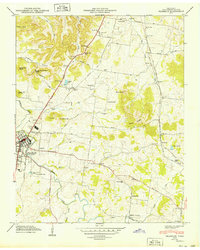 1949 Franklin1949 Print · USGSMid-century Williamson County centers on the thriving town of Franklin and the winding Harpeth River valley before the era of modern subdivision. Genealogists can trace family heritage through dozens of sites like Confederate Cem, Mallory Sch, and the Rest Haven Cem.3 unique versions available
End of results
Showing maps 1-2 of 2
Top cities near Brentwood
- Nashville historical maps
- Murfreesboro historical maps
- Franklin historical maps
- Smyrna historical maps
- Spring Hill historical maps
- La Vergne historical maps
See more
Top neighborhoods of Brentwood
- Murray Estates historical maps
- Brentwood Estates historical maps
- Brentwood Park historical maps
- Dekemont Downs historical maps
- Cambridge Hills historical maps
- Laurel Wood Estates historical maps
See more
Frequently asked questions
- What are the different types of historical maps available for Brentwood?
- What is the oldest map of Brentwood?
- Where can I purchase historical maps of Brentwood for my home or office?
- Where can I download high-res historical maps of Brentwood?
- Are there historical topographic maps available for Brentwood?
- Is there historical aerial imagery available for Brentwood?
- Where are historical maps of Brentwood sourced from?