1960s Maps of Brentwood, Tennessee
Explore 2 historic maps of Brentwood from the 1960s. These maps offer a rare glimpse into what life looked like during the 1960s — showing old roads, neighborhoods, homes, and landmarks that have changed or disappeared over time.
Whether you're researching your family's past, planning a metal detecting trip, or studying how Brentwood's landscape evolved across the 1960s, these high-resolution maps are a powerful tool for exploring the history of this region.
- Focus on a specific era: All maps on this page are from the 1960s, giving you a focused view of this time period.
- See what’s changed: Compare century-old streets, trails, and buildings to today's modern landscape using overlays and satellite layers.
- Research with precision: Use these maps for genealogy, historical research, land use analysis, or educational projects.
- View, download, or print: Maps are fully viewable online in high resolution, and can be downloaded or printed for your own records.
Start exploring Brentwood's history through authentic maps from the 1960s. This is your window into the past.
Brentwood, TN maps
(2)- 1968 Map of Oak Hill
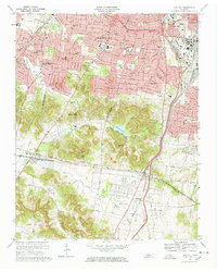 1968 Oak Hill1968 Print · USGSThe affluent suburbs and rugged ridges south of Nashville are captured here in the late sixties as residential growth moved toward the Williamson County line. Researchers can locate long-standing institutions like Harpeth Hall Sch, the Vanderbilt University Observatory, and historical routes like Granny White Pike.5 unique versions available
 - 1968 Map of Antioch, 1971 Print
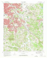 1968 Antioch1971 Print · USGSSoutheast Nashville and the Antioch area are captured here during a period of rapid mid-century growth as suburban neighborhoods began to climb the local ridges. Researchers can locate several family cemeteries and historic landmarks like Central State Hospital, Whitsett Cem, and the Antioch settlement.4 unique versions available
End of results
Showing maps 1-2 of 2
Top cities near Brentwood
- Nashville historical maps
- Murfreesboro historical maps
- Franklin historical maps
- Smyrna historical maps
- Spring Hill historical maps
- La Vergne historical maps
See more
Top neighborhoods of Brentwood
- Murray Estates historical maps
- Brentwood Estates historical maps
- Brentwood Park historical maps
- Dekemont Downs historical maps
- Cambridge Hills historical maps
- Laurel Wood Estates historical maps
See more
Frequently asked questions
- What are the different types of historical maps available for Brentwood?
- What is the oldest map of Brentwood?
- Where can I purchase historical maps of Brentwood for my home or office?
- Where can I download high-res historical maps of Brentwood?
- Are there historical topographic maps available for Brentwood?
- Is there historical aerial imagery available for Brentwood?
- Where are historical maps of Brentwood sourced from?