1980s Maps of Montpier Farms, Tennessee
Explore 2 historic maps of Montpier Farms from the 1980s. These maps offer a rare glimpse into what life looked like during the 1980s — showing old roads, neighborhoods, homes, and landmarks that have changed or disappeared over time.
Whether you're researching your family's past, planning a metal detecting trip, or studying how Montpier Farms's landscape evolved across the 1980s, these high-resolution maps are a powerful tool for exploring the history of this region.
- Focus on a specific era: All maps on this page are from the 1980s, giving you a focused view of this time period.
- See what’s changed: Compare century-old streets, trails, and buildings to today's modern landscape using overlays and satellite layers.
- Research with precision: Use these maps for genealogy, historical research, land use analysis, or educational projects.
- View, download, or print: Maps are fully viewable online in high resolution, and can be downloaded or printed for your own records.
Start exploring Montpier Farms's history through authentic maps from the 1980s. This is your window into the past.
Montpier Farms, TN maps
(2)- 1981 Map of Leipers Fork, 1982 Print
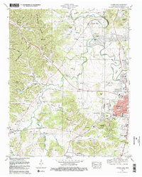 1981 Leipers Fork1982 Print · USGSFranklin and the rural stretches of the West Harpeth River valley are captured in the early eighties as residential growth began to meet historic farmsteads. Genealogists and local historians can trace legacy sites from the Indian Mound and Slave Cem to the Battle Ground Academy.3 unique versions available
 - 1985 Map of Murfreesboro, 1986 Print
 1985 Murfreesboro1986 Print · USGSMiddle Tennessee in the mid-1980s shows a landscape of growing towns and deep-rooted rural outposts. Local researchers can trace old family lines near Bell Buckle, locate landmarks like Donnel Chapel, or explore the grounds of Henry Horton State Park and Hoovers Gap.
End of results
Showing maps 1-2 of 2
Top cities near Montpier Farms
- Nashville historical maps
- Franklin historical maps
- Brentwood historical maps
- Spring Hill historical maps
- North Nashville historical maps
- Fairview historical maps
See more
Frequently asked questions
- What are the different types of historical maps available for Montpier Farms?
- What is the oldest map of Montpier Farms?
- Where can I purchase historical maps of Montpier Farms for my home or office?
- Where can I download high-res historical maps of Montpier Farms?
- Are there historical topographic maps available for Montpier Farms?
- Is there historical aerial imagery available for Montpier Farms?
- Where are historical maps of Montpier Farms sourced from?