1950s Maps of Lebanon, Tennessee
Explore 8 historic maps of Lebanon from the 1950s. These maps offer a rare glimpse into what life looked like during the 1950s — showing old roads, neighborhoods, homes, and landmarks that have changed or disappeared over time.
Whether you're researching your family's past, planning a metal detecting trip, or studying how Lebanon's landscape evolved across the 1950s, these high-resolution maps are a powerful tool for exploring the history of this region.
- Focus on a specific era: All maps on this page are from the 1950s, giving you a focused view of this time period.
- See what’s changed: Compare century-old streets, trails, and buildings to today's modern landscape using overlays and satellite layers.
- Research with precision: Use these maps for genealogy, historical research, land use analysis, or educational projects.
- View, download, or print: Maps are fully viewable online in high resolution, and can be downloaded or printed for your own records.
Start exploring Lebanon's history through authentic maps from the 1950s. This is your window into the past.
Lebanon, TN maps
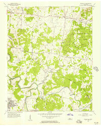
(8)- 1951 Map of Lebanon, 1952 Print
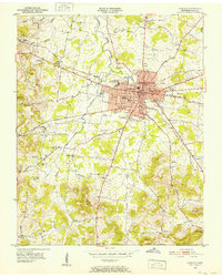 1951 Lebanon1952 Print · USGSMid-century Lebanon and its surrounding Wilson County landscape are captured here just as the post-war era transformed this rail-hub community. Researchers can locate ancestral sites like Bethlehem Ch, the Castle Heights Military Academy, and numerous family burial grounds including Ligon Cem and Greenwood Cem.4 unique versions available
 - 1951 Map of Martha, 1952 Print
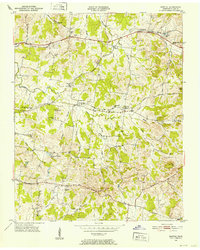 1951 Martha1952 Print · USGSIn the early 1950s, this area of Wilson County was defined by its railroad hamlets and a robust network of community schools. Genealogists and historians can trace family locations through numerous rural landmarks like Beckwith Sch, Rutland Cem, and Old Union Ch.4 unique versions available
 - 1955 Map of Laguardo, 1956 Print
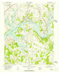 1955 Laguardo1956 Print · USGSThe Cumberland River valley transitioned into a modern utility corridor in the mid-fifties as the reservoir waters rose. Genealogists and historians can trace local landmarks like the Odoms Bend Sch, Franklin Chapel, and the Drive-in Theatre near Laguardo.5 unique versions available
 - 1955 Map of Hunters Point, 1956 Print
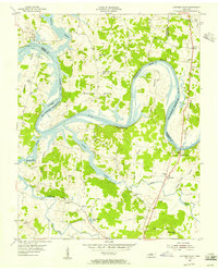 1955 Hunters Point1956 Print · USGSNorth of Lebanon in the mid-1950s, the rising waters of the Old Hickory Reservoir began to transform these historic river bends. Researchers can locate family landmarks like Ebenezer Cem and trace the paths of Coles Ferry Road and Cedar Pike.4 unique versions available
 - 1956 Map of Gladeville, 1957 Print
 1956 Gladeville1957 Print · USGSMid-century Tennessee is captured here as rural crossroads like Gladeville meet military growth at Stewart Air Force Base. Genealogists can trace family landmarks like Browns Cem and the John Colemon Sch among the timber of the Cedars of Lebanon State Forest.5 unique versions available
 - 1956 Map of Nashville, 1971 Print
 1956 Nashville1971 Print · USGSThe Tennessee-Kentucky borderlands come into focus in the mid-1960s as major reservoir projects transformed the Cumberland and Tennessee river valleys. Researchers can trace the rail networks of the Louisville and Nashville and visit sites like Fort Campbell and Fort Donelson National Military Park.2 unique versions available
 - 1958 Map of Shop Springs, 1959 Print
 1958 Shop Springs1959 Print · USGSMid-century Wilson County comes alive through this record of rural Tennessee life and its network of country roads. Genealogists can trace family connections near Shop Springs, Tuckers Crossroads, and the historic Bethlehem Cem.2 unique versions available
 - 1959 Map of Nashville
 1959 Nashville1959 Print · USGSMiddle Tennessee and Southern Kentucky come into focus during the late fifties, showing the region's transition into a modern transportation and military hub. Researchers can trace the sprawling Fort Campbell Military Reservation or locate historic rail stops along the Tennessee Central Ry and Illinois Central RR.
End of results
Showing maps 1-8 of 8
Top cities near Lebanon
- Nashville historical maps
- Hendersonville historical maps
- Smyrna historical maps
- La Vergne historical maps
- Gallatin historical maps
- Mount Juliet historical maps
See more
Top neighborhoods of Lebanon
- Martha historical maps
- Maple Hill historical maps
- Forktown historical maps
- West End Heights historical maps
- Cairo Bend historical maps
- Egan historical maps
See more
Frequently asked questions
- What are the different types of historical maps available for Lebanon?
- What is the oldest map of Lebanon?
- Where can I purchase historical maps of Lebanon for my home or office?
- Where can I download high-res historical maps of Lebanon?
- Are there historical topographic maps available for Lebanon?
- Is there historical aerial imagery available for Lebanon?
- Where are historical maps of Lebanon sourced from?