1940s Maps of Bois d'Arc, Texas
Explore 1 historic maps of Bois d'Arc from the 1940s. These maps offer a rare glimpse into what life looked like during the 1940s — showing old roads, neighborhoods, homes, and landmarks that have changed or disappeared over time.
Whether you're researching your family's past, planning a metal detecting trip, or studying how Bois d'Arc's landscape evolved across the 1940s, these high-resolution maps are a powerful tool for exploring the history of this region.
- Focus on a specific era: All maps on this page are from the 1940s, giving you a focused view of this time period.
- See what’s changed: Compare century-old streets, trails, and buildings to today's modern landscape using overlays and satellite layers.
- Research with precision: Use these maps for genealogy, historical research, land use analysis, or educational projects.
- View, download, or print: Maps are fully viewable online in high resolution, and can be downloaded or printed for your own records.
Start exploring Bois d'Arc's history through authentic maps from the 1940s. This is your window into the past.
Bois d'Arc, TX maps
(1)- 1949 Map of Tennessee Colony, 1967 Print
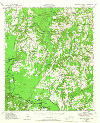 1949 Tennessee Colony1967 Print · USGSAnderson County in the late 1940s shows a landscape of river-bottom lakes and rural communities at the height of the oil boom. Genealogists can locate family landmarks like Judson Cem, Gosman Sch, and the Blackfoot Oil Field.2 unique versions available
End of results
Showing maps 1-1 of 1
Top cities near Bois d'Arc
- Palestine historical maps
- Athens historical maps
- Malakoff historical maps
- Poynor historical maps
- Coffee City historical maps
- Moore Station historical maps
See more
Frequently asked questions
- What are the different types of historical maps available for Bois d'Arc?
- What is the oldest map of Bois d'Arc?
- Where can I purchase historical maps of Bois d'Arc for my home or office?
- Where can I download high-res historical maps of Bois d'Arc?
- Are there historical topographic maps available for Bois d'Arc?
- Is there historical aerial imagery available for Bois d'Arc?
- Where are historical maps of Bois d'Arc sourced from?