1950s Maps of Aransas County, Texas
Explore 18 historic maps of Aransas County from the 1950s. These maps offer a rare glimpse into what life looked like during the 1950s — showing old roads, neighborhoods, homes, and landmarks that have changed or disappeared over time.
Whether you're researching your family's past, planning a metal detecting trip, or studying how Aransas County's landscape evolved across the 1950s, these high-resolution maps are a powerful tool for exploring the history of this region.
- Focus on a specific era: All maps on this page are from the 1950s, giving you a focused view of this time period.
- See what’s changed: Compare century-old streets, trails, and buildings to today's modern landscape using overlays and satellite layers.
- Research with precision: Use these maps for genealogy, historical research, land use analysis, or educational projects.
- View, download, or print: Maps are fully viewable online in high resolution, and can be downloaded or printed for your own records.
Start exploring Aransas County's history through authentic maps from the 1950s. This is your window into the past.
Aransas County, TX maps
(18)- 1950 Map of Corpus Christi, 1953 Print
 1950 Corpus Christi1953 Print · USGSThe South Texas coast comes into focus during the early fifties, showing the interplay between booming oil fields and expansive ranching operations. Genealogists and historians can trace the Texas Mexican rail line through Kingsville or locate heritage sites like Chapman Ranch and Riviera Beach.
 - 1951 Map of Allyns Bight, 1953 Print
 1951 Allyns Bight1953 Print · USGSSt Joseph Island and the Aransas County coast are captured in their mid-century natural state, defined by shifting sands and tidal flats. Researchers can trace the isolated Landing Strip and explore the delicate shoreline of Allyns Bight and Allyn Lake.
 - 1952 Map of St. Charles Bay SW, 1953 Print
 1952 St. Charles Bay SW1953 Print · USGSThe Aransas coast in the early 1950s reveals a wild landscape of shifting shoals and new energy infrastructure. You can trace the path of the Intracoastal Waterway past Deadman Island and the sprawling Mud Flats of Joseph Island.3 unique versions available
 - 1952 Map of St. Charles Bay, 1953 Print
 1952 St. Charles Bay1953 Print · USGSThe Texas Gulf Coast near Aransas Bay comes into focus in the early 1950s, showing a land of tidal bayous and established wildlife conservation. Genealogists and historians can locate family-named landmarks like the Lamar Cem, Ratama Windmill, and the iconic Big Tree.4 unique versions available
 - 1952 Map of Mesquite Bay, 1953 Print
 1952 Mesquite Bay1953 Print · USGSCoastal Texas in the early fifties is defined here by the wild wetlands of the Aransas National Wildlife Refuge and its surrounding bays. You can trace the complex network of barrier islands and inlets, from the Second Chain of Islands to family-named landmarks like Carlos Windmills.4 unique versions available
 - 1952 Map of Tivoli SE, 1953 Print
 1952 Tivoli SE1953 Print · USGSThe Blackjack Peninsula and its coastal marshes are captured in the early fifties, shortly after the establishment of the wildlife refuge. Researchers can find old ranching landmarks like Buzzard Windmill and follow the shoreline from Webb Point to Mustang L.2 unique versions available
 - 1952 Map of Tivoli SW, 1953 Print
 1952 Tivoli SW1953 Print · USGSThe coastal prairie of Refugio and Aransas counties is captured here in the early fifties, showcasing the vital water systems of the Texas coast. Researchers can trace historic ranching infrastructure through named sites like Spanish Village, Lucky Windmill, and Lake Burgentine.
 - 1952 Map of St. Charles Bay SE, 1954 Print
 1952 St. Charles Bay SE1954 Print · USGSThe Aransas and Calhoun county coastlines appear in the early fifties, capturing a wild landscape of barrier islands and tidal flats. Trace ranching and early energy footprints through the Wynne Ranch, the Oil Well, and numerous Windmills.4 unique versions available
 - 1953 Map of Beeville
 1953 Beeville1953 Print · USGSThe Texas Coastal Bend in the early fifties shows a landscape of growing regional hubs and vital maritime corridors. Trace the rail-and-river economy through Goliad, locate the Matagorda Lighthouse, and explore the sprawling Aransas National Wildlife Refuge.
 - 1954 Map of Rockport, 1956 Print
 1954 Rockport1956 Print · USGSThe Aransas County coast comes to life in the mid-fifties, showing the growth of Rockport and the expansion of the Fulton Beach Oil Field. Researchers can locate family landmarks like Mc Lester Cem and trace the early layout of the Aransas County Airport.2 unique versions available
 - 1954 Map of Aransas Pass, 1956 Print
 1954 Aransas Pass1956 Print · USGSMid-century Aransas Pass and Ingleside are documented here during a period of significant industrial and maritime growth along the Texas coast. Researchers can trace the layout of the Aransas Pass Oil Field, locate Kleberg Sch, and identify old sites like the Tarpon Drive-in Theater.2 unique versions available
 - 1954 Map of Woodsboro, 1956 Print
 1954 Woodsboro1956 Print · USGSCoastal Texas in the mid-fifties reveals a landscape defined by the booming oil industry and traditional cotton farming. Researchers can trace the layout of Woodsboro and Sinton, or locate rural landmarks like St Bernard Cem, the Baldwin Cotton Gin, and Roche Ranch.
 - 1954 Map of Vidaurri, 1956 Print
 1954 Vidaurri1956 Print · USGSCoastal Texas ranching and petroleum industry collide in the mid-fifties as massive oil fields expanded across Refugio County. Genealogists and historians can trace family-named sites like Welder Ranch, Lambert Ranch, and the settlements of Vidaurri and Greta.2 unique versions available
 - 1954 Map of Estes, 1956 Print
 1954 Estes1956 Print · USGSThe Aransas coast in the mid-fifties reveals a landscape of barrier islands and early industrial sites like the Carbon Black Plant. Trace historical rail lines through Estes or locate the San Antonio Cem and the Old Terminal.
 - 1954 Map of Port Aransas, 1956 Print
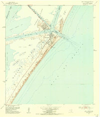 1954 Port Aransas1956 Print · USGSCoastal Texas in the mid-fifties is captured here as a landscape of barrier islands, dredging projects, and maritime industry. Genealogists and historians can trace the early streets of Port Aransas, the location of the Port Aransas Cemetery, and the remote Grant Ranch on Mustang Island.
 - 1954 Map of Aransas Pass, 1964 Print
 1954 Aransas Pass1964 Print · USGSThe Texas Gulf Coast comes alive in the mid-fifties, showing the growth of Aransas Pass and Port Aransas alongside vital rail and shipping corridors. Trace old routes like the Toll Road on Mustang Island and locate sites such as Prairie View Cem or the Coast Guard Station.2 unique versions available
 - 1956 Map of Corpus Christi
 1956 Corpus Christi1956 Print · USGSThe South Texas coast and the burgeoning port of Corpus Christi are captured here during the mid-fifties. Genealogists and historians can trace the rail-and-oil economy through labels like Robstown Airpark, Chapman Ranch, and the Missouri Pacific railroad.
 - 1956 Map of Beeville
 1956 Beeville1956 Print · USGSCoastal Texas and the brush country interior are shown in the mid-fifties, from the coastal bays to the inland oil fields. Trace the old rail lines of the Southern Pacific RR or locate the historic Matagorda Lighthouse and the Aransas National Wildlife Refuge.2 unique versions available
End of results
Showing maps 1-18 of 18
Top cities of Aransas County
Frequently asked questions
- What are the different types of historical maps available for Aransas County?
- What is the oldest map of Aransas County?
- Where can I purchase historical maps of Aransas County for my home or office?
- Where can I download high-res historical maps of Aransas County?
- Are there historical topographic maps available for Aransas County?
- Is there historical aerial imagery available for Aransas County?
- Where are historical maps of Aransas County sourced from?