1960s Maps of Bee County, Texas
Explore 12 historic maps of Bee County from the 1960s. These maps offer a rare glimpse into what life looked like during the 1960s — showing old roads, neighborhoods, homes, and landmarks that have changed or disappeared over time.
Whether you're researching your family's past, planning a metal detecting trip, or studying how Bee County's landscape evolved across the 1960s, these high-resolution maps are a powerful tool for exploring the history of this region.
- Focus on a specific era: All maps on this page are from the 1960s, giving you a focused view of this time period.
- See what’s changed: Compare century-old streets, trails, and buildings to today's modern landscape using overlays and satellite layers.
- Research with precision: Use these maps for genealogy, historical research, land use analysis, or educational projects.
- View, download, or print: Maps are fully viewable online in high resolution, and can be downloaded or printed for your own records.
Start exploring Bee County's history through authentic maps from the 1960s. This is your window into the past.
Bee County, TX maps
(12)- 1960 Map of Beeville
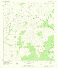
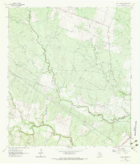
 1960 Beeville1960 Print · USGSCoastal Texas in the mid-fifties reveals a landscape of growing towns and vital military outposts like Foster AFB. Researchers can trace old rail lines including the Missouri Pacific and explore the vast Aransas National Wildlife Refuge.
 - 1961 Map of Crystal City
 1961 Crystal City1961 Print · USGSSouth Texas in the early sixties reveals a landscape of massive cattle ranches and emerging oil fields. Genealogists and historians can trace the Missouri Pacific rail lines through Crystal City, or locate water features like Espantosa Lake and Boynton Reservoir.
 - 1963 Map of Monteola, 1965 Print
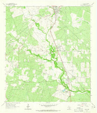
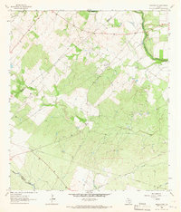
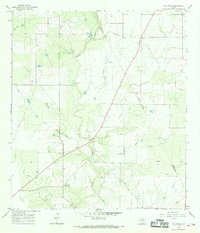
 1963 Monteola1965 Print · USGSThe Bee and Karnes County line comes alive in the early sixties as the oil industry shapes the rural landscape. Researchers can locate family landmarks like Pullin Livingston Cem and Elim Ch or trace the early footprint of the Caesar Oil Field.3 unique versions available
 - 1963 Map of Tuleta, 1965 Print
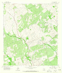
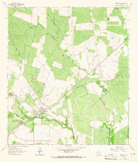
 1963 Tuleta1965 Print · USGSThe Bee County landscape in the early sixties is a study in oil and rail development. Genealogists and historians can trace the Southern Pacific line through Pettus, find family landmarks like Hall Ranch, or locate the Normanna Cem.2 unique versions available
 - 1963 Map of Tulsita, 1965 Print
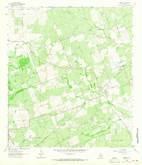
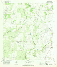
 1963 Tulsita1965 Print · USGSThe Texas oil fields and cattle country come alive in the early sixties as industrial development meets rural settlement. Trace the legacy of petroleum at Burnell Oil Field, locate family roots at Refugio Cem, or follow the Southern Pacific tracks.2 unique versions available
 - 1963 Map of Mineral, 1965 Print
 1963 Mineral1965 Print · USGSThe energy-rich ranchlands of Bee and Live Oak counties are captured here in the early sixties as the regional oil industry reached its height. Researchers can trace family history at Mineral Cemetery or explore the footprints of the Plummer Oil Field and South Texas Childrens Home.2 unique versions available
 - 1963 Map of Lazy F Ranch, 1965 Print
 1963 Lazy F Ranch1965 Print · USGSRanching and early energy extraction define this Bee and Goliad county borderland in the early sixties. Researchers can trace the Southern Pacific rail line, the Dallas Husky Gas Field, and local landmarks like Colony Ch.3 unique versions available
 - 1963 Map of Berclair NW, 1965 Print
 1963 Berclair NW1965 Print · USGSThe borderlands of Bee, Goliad, and Karnes Counties are captured in the early sixties as the regional energy economy expanded. Genealogists and researchers can trace local landmarks like Charco Cem, the San Antonio River, and the Pettus North Oil Field.2 unique versions available
 - 1963 Map of Berclair, 1965 Print
 1963 Berclair1965 Print · USGSGoliad County's brush country comes into focus in the early sixties as the Southern Pacific tracks bisected the village of Berclair. Researchers can trace old property boundaries at the Bee Co Goliad Co line or locate the Myers Cem near the banks of Blanco Creek.2 unique versions available
 - 1965 Map of Pawnee, 1968 Print
 1965 Pawnee1968 Print · USGSPawnee and the surrounding ranch lands of Bee and Karnes counties are captured here in the mid-1960s. Family historians and researchers can trace the rural communities of Nell and El Oso or locate burials at the Nell Cem and Pawnee Cem.2 unique versions available
 - 1965 Map of Ray Point, 1969 Print
 1965 Ray Point1969 Print · USGSSouth Texas ranching and oil country come into focus during the mid-sixties, centered on the Bee and Live Oak County line. Genealogists and researchers can locate Ray Point, Wernli Cem, and scattered Oil Wells across the landscape.2 unique versions available
 - 1968 Map of Crystal City
 1968 Crystal City1968 Print · USGSSouth Texas in the late sixties reveals a landscape shaped by ranching roots and the vital waters of the Nueces River. Researchers can trace the rail-driven growth of Crystal City or locate landmarks like Pilot Knob and Espantosa Lake.
End of results
Showing maps 1-12 of 12
Top cities of Bee County
Frequently asked questions
- What are the different types of historical maps available for Bee County?
- What is the oldest map of Bee County?
- Where can I purchase historical maps of Bee County for my home or office?
- Where can I download high-res historical maps of Bee County?
- Are there historical topographic maps available for Bee County?
- Is there historical aerial imagery available for Bee County?
- Where are historical maps of Bee County sourced from?