1970s Maps of Bee County, Texas
Explore 14 historic maps of Bee County from the 1970s. These maps offer a rare glimpse into what life looked like during the 1970s — showing old roads, neighborhoods, homes, and landmarks that have changed or disappeared over time.
Whether you're researching your family's past, planning a metal detecting trip, or studying how Bee County's landscape evolved across the 1970s, these high-resolution maps are a powerful tool for exploring the history of this region.
- Focus on a specific era: All maps on this page are from the 1970s, giving you a focused view of this time period.
- See what’s changed: Compare century-old streets, trails, and buildings to today's modern landscape using overlays and satellite layers.
- Research with precision: Use these maps for genealogy, historical research, land use analysis, or educational projects.
- View, download, or print: Maps are fully viewable online in high resolution, and can be downloaded or printed for your own records.
Start exploring Bee County's history through authentic maps from the 1970s. This is your window into the past.
Bee County, TX maps
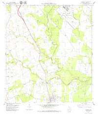
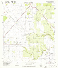
(14)- 1978 Map of Cranell, 1979 Print
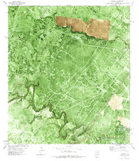 1978 Cranell1979 Print · USGSCoastal Texas ranching and energy production meet in the late seventies along the winding Aransas River. Researchers can trace family-named sites like Rooke Ranch and Alders Camp Windmill or follow the Missouri Pacific rail line through Cranell.
 - 1978 Map of Refugio SW, 1991 Print
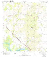
 1978 Refugio SW1991 Print · USGSCoastal Texas ranchlands met industrial expansion in the late seventies as energy production intensified near the Bee County line. Researchers can trace land use patterns across the Blanconia Oil Field and locate rural landmarks like Medio Creek and a local Cem.
 - 1979 Map of Burkes Ridge
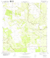
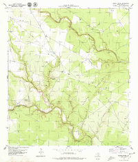 1979 Burkes Ridge1979 Print · USGSBee County ranchlands in the late seventies are defined by the winding paths of the Aransas River and Medio Creek. Researchers can locate family landmarks like Campo Santo (Cem) and trace the energy infrastructure of Oil Wells and a remote Landing Strip.
 - 1979 Map of Tynan
 1979 Tynan1979 Print · USGSCoastal plain ranching and energy development converge in this late 1970s study of the Bee and San Patricio county borders. Genealogists and historians can trace the rail corridors of the Southern Pacific and locate local landmarks like Waldheim Cem and the settlement of Argenta.
 - 1979 Map of Skidmore
 1979 Skidmore1979 Print · USGSSkidmore and the surrounding Bee County ranchlands are captured here in the late seventies, showing a landscape shaped by the rail and river. You can trace the Southern Pacific line past Yougeen to the Evergreen Cemetery and the runways of Chase Field Naval Air Station.
 - 1979 Map of Mulos Hills
 1979 Mulos Hills1979 Print · USGSThe South Texas brush country along the Bee and Live Oak county line is shown here in the late seventies as ranching and energy production shaped the land. Genealogists and historians can trace the Missouri Pacific rail line and locate rural sites like La Para and Mulos Hills Ranch.
 - 1979 Map of Blanconia
 1979 Blanconia1979 Print · USGSDeep in South Texas during the late 1970s, this quadrangle shows the rural intersection of Goliad and Bee counties. Researchers can trace the development of the Blanconia Oil Field and locate landmarks like the local Cem and Blanconia settlement.
 - 1979 Map of Beeville East
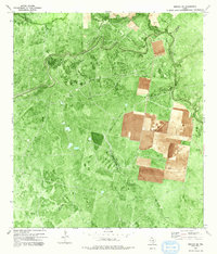
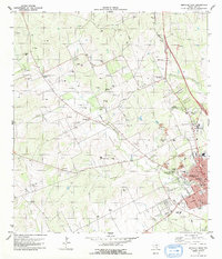
 1979 Beeville East1979 Print · USGSBeeville and its surrounding ranchlands are captured in the late seventies as the town expanded toward the military airfield. Genealogists can trace several local burial sites like Evergreen Cem and Our Lady of Victory No 2 Cem, or locate the Texas A&M University Agricultural Research Station.
 - 1979 Map of Beeville West
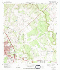
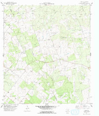
 1979 Beeville West1979 Print · USGSBeeville and its surrounding ranchlands are captured in the late seventies, showing the community's expansion alongside the Southern Pacific tracks. Genealogists and local historians can locate Our Lady of Victory Cemetery, the Friendship Ch, and the rural settlement of Orangedale.
 - 1979 Map of Clareville
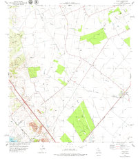
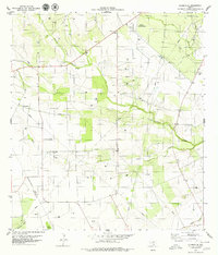 1979 Clareville1979 Print · USGSBee County during the late 1970s shows a landscape transitioning between traditional ranching and intensive oil exploration. Genealogists and local historians can locate the San Pedro Cem, the settlement of Clareville, and the Beeville Municipal Airport.
 - 1979 Map of Cadiz
 1979 Cadiz1979 Print · USGSThe South Texas brush country near the Bee and Live Oak county line is captured here in the late seventies. Family historians and researchers can locate Lebanon Cem and trace the drainage of Poesta Creek and La Parra Creek amidst a landscape of oil and gas exploration.2 unique versions available
 - 1979 Map of Skidmore NE
 1979 Skidmore NE1979 Print · USGSCoastal plains ranch land along the Bee and Goliad county line is captured here in the late seventies. Family researchers can locate the Mucorrera Cemetery and trace the paths of Blanco Creek and Medio Creek across the territory.
 - 1979 Map of Bullshead Creek
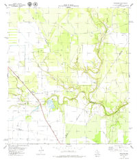
 1979 Bullshead Creek1979 Print · USGSThe South Texas Coastal Bend in the late seventies is captured here, centered on the railroad community of Tynan. Researchers can trace the legacy of local energy production through numerous Oil Wells and find family-named landmarks along Bullshead Creek and Papalote Creek.
 - 1979 Map of Papalote
 1979 Papalote1979 Print · USGSBee County during the late seventies shows a landscape where historic ranching roots meet the energy sector. Researchers can trace the migration of local centers from Old Papalote to the modern townsite, alongside the Papalote Oil Field and the Southern Pacific rail line.
End of results
Showing maps 1-14 of 14
Top cities of Bee County
Frequently asked questions
- What are the different types of historical maps available for Bee County?
- What is the oldest map of Bee County?
- Where can I purchase historical maps of Bee County for my home or office?
- Where can I download high-res historical maps of Bee County?
- Are there historical topographic maps available for Bee County?
- Is there historical aerial imagery available for Bee County?
- Where are historical maps of Bee County sourced from?