1990s Maps of Saint Hedwig, Texas
Explore 3 historic maps of Saint Hedwig from the 1990s. These maps offer a rare glimpse into what life looked like during the 1990s — showing old roads, neighborhoods, homes, and landmarks that have changed or disappeared over time.
Whether you're researching your family's past, planning a metal detecting trip, or studying how Saint Hedwig's landscape evolved across the 1990s, these high-resolution maps are a powerful tool for exploring the history of this region.
- Focus on a specific era: All maps on this page are from the 1990s, giving you a focused view of this time period.
- See what’s changed: Compare century-old streets, trails, and buildings to today's modern landscape using overlays and satellite layers.
- Research with precision: Use these maps for genealogy, historical research, land use analysis, or educational projects.
- View, download, or print: Maps are fully viewable online in high resolution, and can be downloaded or printed for your own records.
Start exploring Saint Hedwig's history through authentic maps from the 1990s. This is your window into the past.
Saint Hedwig, TX maps
(3)- 1992 Map of Martinez
 1992 Martinez1992 Print · USGSBexar County's eastern landscape is shown in the early nineties as suburban expansion met established rural settlements. Family historians can trace roots through the St Jerome Ch and Salem Cem, or locate the Martindale Army Airfield.
 - 1992 Map of La Vernia SW
 1992 La Vernia SW1992 Print · USGSWilson County and the Bexar border are shown in the early nineties as a landscape defined by oil production and rural life. Researchers can trace family roots at La Vernia Cem or explore industrial history at the Cooksey Oil Field and Old Railroad Grade.
 - 1992 Map of Saint Hedwig
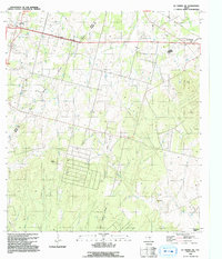
 1992 Saint Hedwig1992 Print · USGSBexar County's rural eastern edge is documented in the early nineties, showing a landscape of creek-side settlements and legacy rail lines. Researchers can trace historic family routes along Graytown Road or locate landmarks like Hebron Ch and Sculls Crossing (Ford).
End of results
Showing maps 1-3 of 3
Top cities near Saint Hedwig
- San Antonio historical maps
- New Braunfels historical maps
- Schertz historical maps
- Seguin historical maps
- Universal City historical maps
- Converse historical maps
See more
Frequently asked questions
- What are the different types of historical maps available for Saint Hedwig?
- What is the oldest map of Saint Hedwig?
- Where can I purchase historical maps of Saint Hedwig for my home or office?
- Where can I download high-res historical maps of Saint Hedwig?
- Are there historical topographic maps available for Saint Hedwig?
- Is there historical aerial imagery available for Saint Hedwig?
- Where are historical maps of Saint Hedwig sourced from?