1900s (20th Century) Maps of Kurten, Texas
Explore 5 historic maps of Kurten from the 1900s (20th Century). These maps offer a rare glimpse into what life looked like during the 1900s — showing old roads, neighborhoods, homes, and landmarks that have changed or disappeared over time.
Whether you're researching your family's past, planning a metal detecting trip, or studying how Kurten's landscape evolved across the 1900s, these high-resolution maps are a powerful tool for exploring the history of this region.
- Focus on a specific era: All maps on this page are from the 1900s, giving you a focused view of this time period.
- See what’s changed: Compare century-old streets, trails, and buildings to today's modern landscape using overlays and satellite layers.
- Research with precision: Use these maps for genealogy, historical research, land use analysis, or educational projects.
- View, download, or print: Maps are fully viewable online in high resolution, and can be downloaded or printed for your own records.
Start exploring Kurten's history through authentic maps from the 1900s. This is your window into the past.
Kurten, TX maps
(5)- 1931 Map of Iola
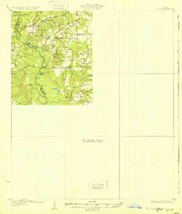 1931 Iola1931 Print · USGSThe Navasota River basin in the mid-1920s shows a landscape of river-bottom lakes and rural outposts. Genealogists can locate family landmarks like Keefer Cem and Nash Cem or the local hub at Burns Store.2 unique versions available
 - 1954 Map of Austin, 1964 Print
 1954 Austin1964 Print · USGSCentral Texas is captured during a period of steady growth as the capital city and its neighboring farm towns began to modernize. Researchers can trace historic rail corridors like the Southern Pacific RR or locate landmarks such as Bergstrom Air Force Base and Pilot Knob.4 unique versions available
 - 1959 Map of Clear Lake, 1960 Print
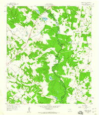 1959 Clear Lake1960 Print · USGSThe Navasota River bottomlands are captured here in the late fifties at the meeting of Brazos, Madison, and Grimes Counties. Researchers can trace rural landmarks like Williamson Cem, find old river transits at Democrat Crossing, or locate Brushy Lake.3 unique versions available
 - 1963 Map of Kurten, 1964 Print
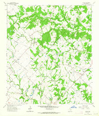 1963 Kurten1964 Print · USGSBrazos County is captured in the early sixties as a region of tight-knit rural communities and family landholdings. Researchers can locate numerous family burial sites and country churches, including Schultze Cem, Cottonwood Ch, and the settlement of Kurten.2 unique versions available
 - 1993 Map of Bryan
 1993 Bryan1993 Print · USGSBrazos Valley life in the early nineties centered on the rapid growth of College Station and the agricultural heartbeat of the river bottomlands. Genealogists and historians can trace the paths of the Kings Highway, several rail lines, and local landmarks like City Cem and Texas A&M University.
End of results
Showing maps 1-5 of 5
Top cities near Kurten
- College Station historical maps
- Bryan historical maps
- Franklin historical maps
- Wixon Valley historical maps
Frequently asked questions
- What are the different types of historical maps available for Kurten?
- What is the oldest map of Kurten?
- Where can I purchase historical maps of Kurten for my home or office?
- Where can I download high-res historical maps of Kurten?
- Are there historical topographic maps available for Kurten?
- Is there historical aerial imagery available for Kurten?
- Where are historical maps of Kurten sourced from?