1900s (20th Century) Maps of San Antonio Prairie, Texas
Explore 4 historic maps of San Antonio Prairie from the 1900s (20th Century). These maps offer a rare glimpse into what life looked like during the 1900s — showing old roads, neighborhoods, homes, and landmarks that have changed or disappeared over time.
Whether you're researching your family's past, planning a metal detecting trip, or studying how San Antonio Prairie's landscape evolved across the 1900s, these high-resolution maps are a powerful tool for exploring the history of this region.
- Focus on a specific era: All maps on this page are from the 1900s, giving you a focused view of this time period.
- See what’s changed: Compare century-old streets, trails, and buildings to today's modern landscape using overlays and satellite layers.
- Research with precision: Use these maps for genealogy, historical research, land use analysis, or educational projects.
- View, download, or print: Maps are fully viewable online in high resolution, and can be downloaded or printed for your own records.
Start exploring San Antonio Prairie's history through authentic maps from the 1900s. This is your window into the past.
San Antonio Prairie, TX maps
(4)- 1919 Map of Dime Box, 1956 Print
 1919 Dime Box1956 Print · USGSLee County and the surrounding Texas Brazos Valley are shown here just after the Great War, during a period of shifting settlements. Genealogists can trace early homesteads and community hubs near Old Dime Box, Loebau, and Shady Grove School.
 - 1954 Map of Austin, 1964 Print
 1954 Austin1964 Print · USGSCentral Texas is captured during a period of steady growth as the capital city and its neighboring farm towns began to modernize. Researchers can trace historic rail corridors like the Southern Pacific RR or locate landmarks such as Bergstrom Air Force Base and Pilot Knob.4 unique versions available
 - 1960 Map of Deanville, 1963 Print
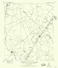
 1960 Deanville1963 Print · USGSBurleson and Lee counties in the early sixties reveal a landscape of rural schoolhouses and family cemeteries along the railroad. Genealogists can locate Sulphur Spring School, San Antonio Prairie Cemetery, and the original site of Old Dime Box.3 unique versions available
 - 1993 Map of Brenham
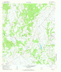
 1993 Brenham1993 Print · USGSTexas river country and the birthplace of the republic are showcased in the early nineties, centered on the confluence of the Brazos and Navasota. Researchers can trace the rail sidings of the Southern Pacific RR and locate historic community landmarks like St Paul Ch and Washington-on-the-Brazos State Park.
End of results
Showing maps 1-4 of 4
Top cities near San Antonio Prairie
Frequently asked questions
- What are the different types of historical maps available for San Antonio Prairie?
- What is the oldest map of San Antonio Prairie?
- Where can I purchase historical maps of San Antonio Prairie for my home or office?
- Where can I download high-res historical maps of San Antonio Prairie?
- Are there historical topographic maps available for San Antonio Prairie?
- Is there historical aerial imagery available for San Antonio Prairie?
- Where are historical maps of San Antonio Prairie sourced from?