1960s Maps of Double Horn, Texas
Explore 2 historic maps of Double Horn from the 1960s. These maps offer a rare glimpse into what life looked like during the 1960s — showing old roads, neighborhoods, homes, and landmarks that have changed or disappeared over time.
Whether you're researching your family's past, planning a metal detecting trip, or studying how Double Horn's landscape evolved across the 1960s, these high-resolution maps are a powerful tool for exploring the history of this region.
- Focus on a specific era: All maps on this page are from the 1960s, giving you a focused view of this time period.
- See what’s changed: Compare century-old streets, trails, and buildings to today's modern landscape using overlays and satellite layers.
- Research with precision: Use these maps for genealogy, historical research, land use analysis, or educational projects.
- View, download, or print: Maps are fully viewable online in high resolution, and can be downloaded or printed for your own records.
Start exploring Double Horn's history through authentic maps from the 1960s. This is your window into the past.
Double Horn, TX maps
(2)- 1967 Map of Spicewood, 1969 Print
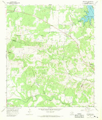 1967 Spicewood1969 Print · USGSThe Blanco and Burnet county line is shown here in the late sixties as the rising waters of the Colorado River reshaped the land. Trace family history at Holloway Cem or follow the old paths near Spicewood and Cypress Mill.4 unique versions available
 - 1967 Map of Smithwick, 1969 Print
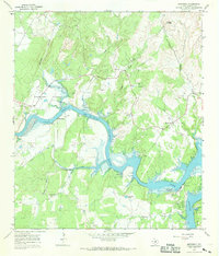 1967 Smithwick1969 Print · USGSThe Colorado River valley in Burnet County is shown here during the late 1960s as the landscape adapted to the presence of the lake. Local researchers can trace numerous family burial sites like Richland Cem and Burnam Cem or locate the Spicewood Beach Landing Strip.3 unique versions available
End of results
Showing maps 1-2 of 2
Top cities near Double Horn
- Lakeway historical maps
- Marble Falls historical maps
- Burnet historical maps
- Lago Vista historical maps
- Horseshoe Bay historical maps
- Bee Cave historical maps
See more
Frequently asked questions
- What are the different types of historical maps available for Double Horn?
- What is the oldest map of Double Horn?
- Where can I purchase historical maps of Double Horn for my home or office?
- Where can I download high-res historical maps of Double Horn?
- Are there historical topographic maps available for Double Horn?
- Is there historical aerial imagery available for Double Horn?
- Where are historical maps of Double Horn sourced from?