1990s Maps of Port Lavaca, Texas
Explore 4 historic maps of Port Lavaca from the 1990s. These maps offer a rare glimpse into what life looked like during the 1990s — showing old roads, neighborhoods, homes, and landmarks that have changed or disappeared over time.
Whether you're researching your family's past, planning a metal detecting trip, or studying how Port Lavaca's landscape evolved across the 1990s, these high-resolution maps are a powerful tool for exploring the history of this region.
- Focus on a specific era: All maps on this page are from the 1990s, giving you a focused view of this time period.
- See what’s changed: Compare century-old streets, trails, and buildings to today's modern landscape using overlays and satellite layers.
- Research with precision: Use these maps for genealogy, historical research, land use analysis, or educational projects.
- View, download, or print: Maps are fully viewable online in high resolution, and can be downloaded or printed for your own records.
Start exploring Port Lavaca's history through authentic maps from the 1990s. This is your window into the past.
Port Lavaca, TX maps
(4)- 1995 Map of Port Lavaca East
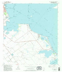 1995 Port Lavaca East1995 Print · USGSCoastal Calhoun County in the mid-nineties shows the enduring legacy of early Texas settlements along the Gulf. Researchers can trace the proximity of the Historical Monument to Indianola Cem and the residential growth at Alamo Beach.
 - 1995 Map of Kamey
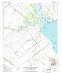 1995 Kamey1995 Print · USGSThe Texas coast near Port Lavaca comes alive in this mid-nineties survey of the tidal wetlands and industrial infrastructure. Researchers can trace the layout of the Oil and Gas Field, locate the Sixmile Ch, and see the early development of Port Lavaca.
 - 1995 Map of Port Lavaca West
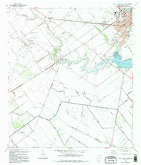 1995 Port Lavaca West1995 Print · USGSCoastal Texas development meets the petroleum industry in the 1990s near the shores of Chocolate Bay. Trace the growth of Port Lavaca and its local landmarks, from Colonial Gardens Cem to the regional Tanner Airport.
 - 1995 Map of Point Comfort
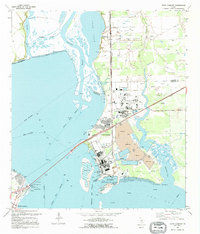 1995 Point Comfort1995 Print · USGSThe industrial heart of the Texas Gulf Coast is on display in the 1990s as processing plants and shipping channels define the shoreline. Researchers can trace the massive Chemical Plant complex and locate recreational landmarks like Lighthouse Beach and Noble Point.
End of results
Showing maps 1-4 of 4
Top cities near Port Lavaca
- Seadrift historical maps
- Port O'Connor historical maps
- Point Comfort historical maps
- La Ward historical maps
- Austwell historical maps
Frequently asked questions
- What are the different types of historical maps available for Port Lavaca?
- What is the oldest map of Port Lavaca?
- Where can I purchase historical maps of Port Lavaca for my home or office?
- Where can I download high-res historical maps of Port Lavaca?
- Are there historical topographic maps available for Port Lavaca?
- Is there historical aerial imagery available for Port Lavaca?
- Where are historical maps of Port Lavaca sourced from?