1930s Maps of Bayview, Texas
Explore 5 historic maps of Bayview from the 1930s. These maps offer a rare glimpse into what life looked like during the 1930s — showing old roads, neighborhoods, homes, and landmarks that have changed or disappeared over time.
Whether you're researching your family's past, planning a metal detecting trip, or studying how Bayview's landscape evolved across the 1930s, these high-resolution maps are a powerful tool for exploring the history of this region.
- Focus on a specific era: All maps on this page are from the 1930s, giving you a focused view of this time period.
- See what’s changed: Compare century-old streets, trails, and buildings to today's modern landscape using overlays and satellite layers.
- Research with precision: Use these maps for genealogy, historical research, land use analysis, or educational projects.
- View, download, or print: Maps are fully viewable online in high resolution, and can be downloaded or printed for your own records.
Start exploring Bayview's history through authentic maps from the 1930s. This is your window into the past.
Bayview, TX maps
(5)- 1930 Map of Los Fresnos
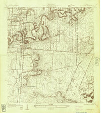 1930 Los Fresnos1930 Print · USGSCameron County's agricultural and rail landscape is captured here in the early thirties. Genealogists can trace early homesteads near Los Fresnos or locate landmarks like the Palo Alto Battlefield Monument and White House Sch.
 - 1930 Map of Laguna Atascosa
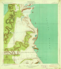
 1930 Laguna Atascosa1930 Print · USGSDeep in South Texas in the early thirties, this survey reveals a landscape of working cattle ranches and coastal lagoons. Genealogists and historians can trace family holdings like El Alazan Ranch and San Pedro Ranch or locate the old San Jose settlement.
 - 1934 Map of La Coma
 1934 La Coma1934 Print · USGSCoastal Cameron County comes to life in the early thirties, showing the intricate resacas and shoreline settlements before the modern era. Genealogists and historians can trace the tracks of the Missouri Pacific RR past Abney and locate the historic La Coma Ranch.3 unique versions available
 - 1936 Map of Laguna Atascosa
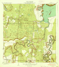 1936 Laguna Atascosa1936 Print · USGSCoastal Cameron County in the mid-1930s was a landscape of ancestral ranches and winding waterways. Genealogists and historians can trace family landholdings like La Tina Ranch and Palo Blanco Ranch or follow the path of the Missouri Pacific Railroad past Lacoma.2 unique versions available
 - 1936 Map of Los Fresnos
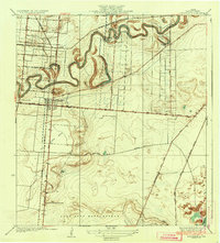 1936 Los Fresnos1936 Print · USGSThe Lower Rio Grande Valley landscape comes into focus during the 1930s, highlighting a network of irrigation ditches and historical battle sites. Researchers can trace the winding Resaca de los Cuates or locate vanished landmarks like the Palo Alto Battlefield Monument and White House Sch.3 unique versions available
End of results
Showing maps 1-5 of 5
Top cities near Bayview
- Brownsville historical maps
- San Benito historical maps
- Cameron Park historical maps
- Los Fresnos historical maps
- Port Isabel historical maps
- Laguna Vista historical maps
See more
Frequently asked questions
- What are the different types of historical maps available for Bayview?
- What is the oldest map of Bayview?
- Where can I purchase historical maps of Bayview for my home or office?
- Where can I download high-res historical maps of Bayview?
- Are there historical topographic maps available for Bayview?
- Is there historical aerial imagery available for Bayview?
- Where are historical maps of Bayview sourced from?