1960s Maps of Pittsburg, Texas
Explore 2 historic maps of Pittsburg from the 1960s. These maps offer a rare glimpse into what life looked like during the 1960s — showing old roads, neighborhoods, homes, and landmarks that have changed or disappeared over time.
Whether you're researching your family's past, planning a metal detecting trip, or studying how Pittsburg's landscape evolved across the 1960s, these high-resolution maps are a powerful tool for exploring the history of this region.
- Focus on a specific era: All maps on this page are from the 1960s, giving you a focused view of this time period.
- See what’s changed: Compare century-old streets, trails, and buildings to today's modern landscape using overlays and satellite layers.
- Research with precision: Use these maps for genealogy, historical research, land use analysis, or educational projects.
- View, download, or print: Maps are fully viewable online in high resolution, and can be downloaded or printed for your own records.
Start exploring Pittsburg's history through authentic maps from the 1960s. This is your window into the past.
Pittsburg, TX maps
(2)- 1960 Map of Pittsburg, 1962 Print
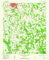 1960 Pittsburg1962 Print · USGSNorthwest of the Piney Woods in the early sixties, Pittsburg appears as a bustling railroad junction where two major lines meet. Genealogists can trace rural family life through numerous landmarks like Smart Cem, Union Chapel, and St Merner Ch.2 unique versions available
 - 1964 Map of Harvard, 1967 Print
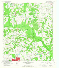 1964 Harvard1967 Print · USGSIn the mid-1960s, the rural landscapes of Titus and Camp Counties were defined by the winding Big Cypress Creek and the intersection of major rail lines. Genealogists can trace family footprints at Concord Cem, North Chapel Cem, and old church sites like East New Hope Ch.
End of results
Showing maps 1-2 of 2
Top cities near Pittsburg
- Mount Pleasant historical maps
- Daingerfield historical maps
- Omaha historical maps
- Winfield historical maps
- Miller's Cove historical maps
- Rocky Mound historical maps
Top neighborhoods of Pittsburg
Frequently asked questions
- What are the different types of historical maps available for Pittsburg?
- What is the oldest map of Pittsburg?
- Where can I purchase historical maps of Pittsburg for my home or office?
- Where can I download high-res historical maps of Pittsburg?
- Are there historical topographic maps available for Pittsburg?
- Is there historical aerial imagery available for Pittsburg?
- Where are historical maps of Pittsburg sourced from?