1960s Maps of Carson County, Texas
Explore 12 historic maps of Carson County from the 1960s. These maps offer a rare glimpse into what life looked like during the 1960s — showing old roads, neighborhoods, homes, and landmarks that have changed or disappeared over time.
Whether you're researching your family's past, planning a metal detecting trip, or studying how Carson County's landscape evolved across the 1960s, these high-resolution maps are a powerful tool for exploring the history of this region.
- Focus on a specific era: All maps on this page are from the 1960s, giving you a focused view of this time period.
- See what’s changed: Compare century-old streets, trails, and buildings to today's modern landscape using overlays and satellite layers.
- Research with precision: Use these maps for genealogy, historical research, land use analysis, or educational projects.
- View, download, or print: Maps are fully viewable online in high resolution, and can be downloaded or printed for your own records.
Start exploring Carson County's history through authentic maps from the 1960s. This is your window into the past.
Carson County, TX maps
(12)- 1960 Map of Claude, 1961 Print
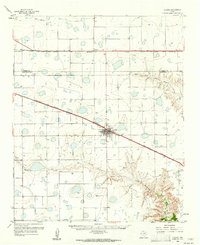 1960 Claude1961 Print · USGSThe Texas Panhandle cattle country around the 1960s is defined here by the confluence of major railroads and the rugged breaks of the Red River. Trace the path of the Burlington line into Claude or locate landmarks like Conway and Mulberry Creek.2 unique versions available
 - 1960 Map of Groom, 1961 Print
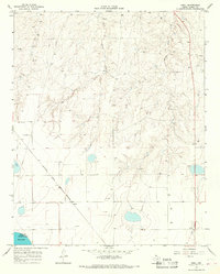
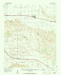 1960 Groom1961 Print · USGSThe Texas Panhandle plains meet the breaks of the Red River in the 1960s, where ranching culture and rail lines converge. Genealogists and historians can locate family landmarks like the Goodnight Cem and trace cattle operations at Thornberry Ranch or SJ Ranch.
 - 1963 Map of Skellytown, 1968 Print
 1963 Skellytown1968 Print · USGSThe Texas Panhandle industrial landscape comes to life in the early 1960s as petroleum production defines the region. Trace energy history and rail lines through Skellytown, the Carbon Black Plant, and the ATCHISON TOPEKA AND SANTA FE railroad.
 - 1965 Map of White Deer, 1967 Print
 1965 White Deer1967 Print · USGSThe Texas Panhandle town of White Deer appears here during its mid-century industrial peak, centered on the ATCHISON TOPEKA AND SANTA FE railroad. Researchers can locate family sites at Sacred Heart Cem and trace the extensive OIL FIELD surrounding the community.
 - 1965 Map of Abell, 1967 Print
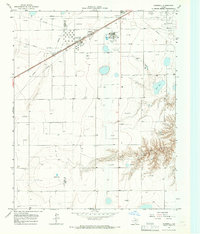
 1965 Abell1967 Print · USGSCarson County's industrial High Plains landscape is captured here in the mid-sixties, dominated by energy extraction and the railroad. Researchers can trace the ATCHISON TOPEKA AND SANTA FE line through Abell and Pomeroy, or locate the Military Reservation near Pantex Lake.
 - 1965 Map of Lake Mc Connell, 1967 Print
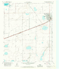
 1965 Lake Mc Connell1967 Print · USGSGray County, Texas, was a hub of energy and transport in the mid-1960s as petroleum infrastructure reshaped the Panhandle. Researchers can trace the industrial footprint of the Carbon Black Plant, the residential layout of Kingsmill Camp, and the rail lines of the Atchison Topeka and Santa Fe.
 - 1966 Map of Grandview School, 1967 Print
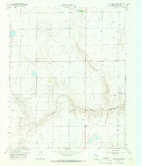
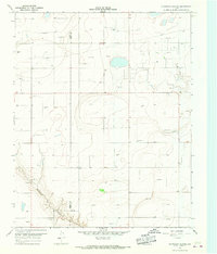 1966 Grandview School1967 Print · USGSThe high plains of the Texas Panhandle are captured here in the mid-sixties, straddling the Carson Co and Gray Co line. Local historians and researchers can locate Grandview Sch, trace the path of McClellan Creek, and identify early Oil Wells.
 - 1966 Map of Panhandle West, 1967 Print
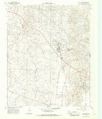
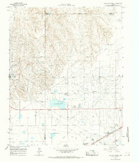
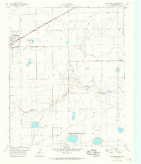
 1966 Panhandle West1967 Print · USGSThe High Plains of Carson County come into focus in the mid-1960s, centered on the rail hub of Panhandle. Genealogists and historians can trace the early township at Lee, locate the landmark Bois d'Arc Tree, and explore the infrastructure of the Military Reservation.
 - 1966 Map of Panhandle East, 1967 Print
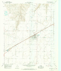
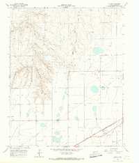
 1966 Panhandle East1967 Print · USGSCarson County's high plains economy is on full display in the mid-1960s as the railroad and agricultural industry converge. Trace the rail siding at Panhandle past the Grain Elevator or locate rural landmarks like Heaston and the local Cem.
 - 1966 Map of Cuyler, 1967 Print
 1966 Cuyler1967 Print · USGSCarson County during the mid-sixties reveals a landscape defined by petroleum extraction and rail transport. Researchers can trace the industrial footprint of the Atchison Topeka and Santa Fe line, the silos at Cuyler, and scattered Oil Wells.2 unique versions available
 - 1966 Map of White Deer SW, 1967 Print
 1966 White Deer SW1967 Print · USGSCarson County in the mid-1960s shows a landscape transformed by energy production along the breaks of the High Plains. Genealogists and industrial historians can trace the specific locations of numerous Oil Wells, Gas Wells, and the McClellan Creek drainage system.
 - 1966 Map of Kingsmill, 1967 Print
 1966 Kingsmill1967 Print · USGSThe Texas Panhandle's energy and rail landscape is on full display in the mid-sixties, from the Kingsmill rail stop to the Oil Field operations. Trace the industrial footprint of the Chemical Plant, the Pampa Plant (Gas), and the rail-side Kingsmill Camp.
End of results
Showing maps 1-12 of 12
Top cities of Carson County
Frequently asked questions
- What are the different types of historical maps available for Carson County?
- What is the oldest map of Carson County?
- Where can I purchase historical maps of Carson County for my home or office?
- Where can I download high-res historical maps of Carson County?
- Are there historical topographic maps available for Carson County?
- Is there historical aerial imagery available for Carson County?
- Where are historical maps of Carson County sourced from?