1990s Maps of The Plantation on Cotton Bayou, Chambers County
Explore 2 historic maps of The Plantation on Cotton Bayou from the 1990s. These maps offer a rare glimpse into what life looked like during the 1990s — showing old roads, neighborhoods, homes, and landmarks that have changed or disappeared over time.
Whether you're researching your family's past, planning a metal detecting trip, or studying how The Plantation on Cotton Bayou's landscape evolved across the 1990s, these high-resolution maps are a powerful tool for exploring the history of this region.
- Focus on a specific era: All maps on this page are from the 1990s, giving you a focused view of this time period.
- See what’s changed: Compare century-old streets, trails, and buildings to today's modern landscape using overlays and satellite layers.
- Research with precision: Use these maps for genealogy, historical research, land use analysis, or educational projects.
- View, download, or print: Maps are fully viewable online in high resolution, and can be downloaded or printed for your own records.
Start exploring The Plantation on Cotton Bayou's history through authentic maps from the 1990s. This is your window into the past.
The Plantation on Cotton Bayou, Chambers County maps
(2)- 1993 Map of Cove
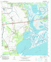 1993 Cove1993 Print · USGSThe coastal wetlands and bayous of Chambers County are captured in the early nineties as industry and nature meet near the bay. Trace local heritage and infrastructure through landmarks like the Winfree Cemetery, Barbers Hill Schools, and the Trinity Bay Oil Field.
 - 1995 Map of Cove, 2000 Print
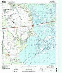 1995 Cove2000 Print · USGSThe Trinity River delta and Chambers County coast are captured here in the mid-nineties, showing a landscape of oil fields and winding bayous. Genealogists can trace family sites at Winfree Cemetery and St Emily Ch or locate the old Lost Cem.
End of results
Showing maps 1-2 of 2
Frequently asked questions
- What are the different types of historical maps available for The Plantation on Cotton Bayou?
- What is the oldest map of The Plantation on Cotton Bayou?
- Where can I purchase historical maps of The Plantation on Cotton Bayou for my home or office?
- Where can I download high-res historical maps of The Plantation on Cotton Bayou?
- Are there historical topographic maps available for The Plantation on Cotton Bayou?
- Is there historical aerial imagery available for The Plantation on Cotton Bayou?
- Where are historical maps of The Plantation on Cotton Bayou sourced from?