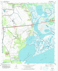
1993 Map of Cove
USGS Topo · Published 1993About this map
Trinity River waters and the labyrinthine bayous of the Texas Gulf Coast define this landscape as it appeared in the early 1990s. The settlement of Old River-Winfree sits at the north, while Cove and Beach City occupy the lower reaches near the Trinity Bay Oil Field. This survey records a complex network of wetlands and inland lakes, including Lost Lake, Cotton Lake, and Round Lake, many of which are interconnected by channels like Cotton Bayou and Cross Bayou. Genealogical value is found in the numerous family and community burial grounds, such as Tilton Cem, Icet Cem, and the Winfree Cemetery. Infrastructure for the local petroleum industry and aviation is prominent, including several Oil Wells, a Radio Tower, and the RWJ Airpark near the shore of South Cotton Lake.
Find a feature on this map
74 named features on this map. Tap any name to fly to it.
Don’t see what you’re looking for? This feature index may not catch every label — zoom into the map to look around manually.
Map Details
Editions of this 1993 Cove Map
This is the sole edition of this map. No revisions or reprints were ever made.
Other maps of this area

1916 · Morgan Point
USGS Topo · 1:24,000

1916 · Cedar Bayou
USGS Topo · 1:24,000

1919 · Morgan Point
USGS Topo · 1:31,680

1919 · Cedar Bayou
USGS Topo · 1:31,680

1942 · Anahuac
USGS Topo · 1:24,000

1943 · West of Eagle
USGS Topo · 1:31,680
1943 · Morgan Point
USGS Topo · 1:31,680

1943 · Cedar Bayou
USGS Topo · 1:24,000

1950 · Houston
USGS Topo · 1:250,000
1956 · Morgan Point
USGS Topo · 1:24,000