1960s Maps of Bronte, Texas
Explore 3 historic maps of Bronte from the 1960s. These maps offer a rare glimpse into what life looked like during the 1960s — showing old roads, neighborhoods, homes, and landmarks that have changed or disappeared over time.
Whether you're researching your family's past, planning a metal detecting trip, or studying how Bronte's landscape evolved across the 1960s, these high-resolution maps are a powerful tool for exploring the history of this region.
- Focus on a specific era: All maps on this page are from the 1960s, giving you a focused view of this time period.
- See what’s changed: Compare century-old streets, trails, and buildings to today's modern landscape using overlays and satellite layers.
- Research with precision: Use these maps for genealogy, historical research, land use analysis, or educational projects.
- View, download, or print: Maps are fully viewable online in high resolution, and can be downloaded or printed for your own records.
Start exploring Bronte's history through authentic maps from the 1960s. This is your window into the past.
Bronte, TX maps
(3)- 1961 Map of Shawville, 1962 Print
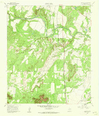 1961 Shawville1962 Print · USGSCoke County's river valley and rail corridor are captured here in the early 1960s. Genealogists and historians can trace the development of Shawville and the Fort Chadbourne Oil Field or locate landmarks like Cedar Mtn.2 unique versions available
 - 1961 Map of Bronte, 1962 Print
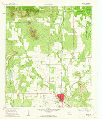 1961 Bronte1962 Print · USGSCoke County in the early sixties reveals a landscape defined by the West Texas petroleum boom and the historic cattle country around Bronte. Researchers can trace the Panhandle and Santa Fe rail line or locate family sites near the Fort Chadbourne Cemetery and Fairview Cemetery.2 unique versions available
 - 1965 Map of San Angelo
 1965 San Angelo1965 Print · USGSWest Texas in the mid-sixties reveals a landscape shaped by the petroleum industry and strategic water management. Genealogists and historians can trace the rail corridor through Texon and Big Lake, or locate military landmarks like Goodfellow AFB and Broome Air Force Auxiliary Airfield.
End of results
Showing maps 1-3 of 3
Top cities near Bronte
Frequently asked questions
- What are the different types of historical maps available for Bronte?
- What is the oldest map of Bronte?
- Where can I purchase historical maps of Bronte for my home or office?
- Where can I download high-res historical maps of Bronte?
- Are there historical topographic maps available for Bronte?
- Is there historical aerial imagery available for Bronte?
- Where are historical maps of Bronte sourced from?