1960s Maps of McKinney, Texas
Explore 6 historic maps of McKinney from the 1960s. These maps offer a rare glimpse into what life looked like during the 1960s — showing old roads, neighborhoods, homes, and landmarks that have changed or disappeared over time.
Whether you're researching your family's past, planning a metal detecting trip, or studying how McKinney's landscape evolved across the 1960s, these high-resolution maps are a powerful tool for exploring the history of this region.
- Focus on a specific era: All maps on this page are from the 1960s, giving you a focused view of this time period.
- See what’s changed: Compare century-old streets, trails, and buildings to today's modern landscape using overlays and satellite layers.
- Research with precision: Use these maps for genealogy, historical research, land use analysis, or educational projects.
- View, download, or print: Maps are fully viewable online in high resolution, and can be downloaded or printed for your own records.
Start exploring McKinney's history through authentic maps from the 1960s. This is your window into the past.
McKinney, TX maps
(6)- 1960 Map of Frisco, 1961 Print
 1960 Frisco1961 Print · USGSThe rural landscape of Collin County appears here just as the post-war era began to shape North Texas. Researchers can trace the early rail-side footprints of Frisco and Prosper, or locate family landmarks like Bethel Cem and the Rockhill Sch.5 unique versions available
 - 1960 Map of McKinney East, 1961 Print
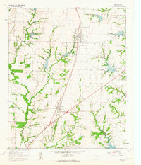
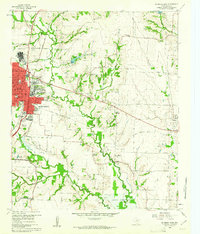 1960 McKinney East1961 Print · USGSCollin County's transition from rural farming to mid-century growth is visible here as the eastern edge of McKinney meets the river. Researchers can locate family landmarks like Pine Grove Cemetery and historic rural hubs including New Hope and Milligan.4 unique versions available
 - 1960 Map of McKinney West, 1962 Print
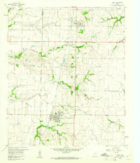
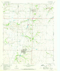
 1960 McKinney West1962 Print · USGSCollin County was on the cusp of significant growth in the early sixties as McKinney expanded westward across the creeks. Genealogists and local historians can trace family sites like McGarrah Cem, the Buckner (Site), and the Stimson Cem.4 unique versions available
 - 1961 Map of Weston, 1963 Print
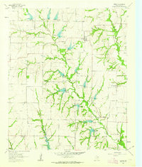 1961 Weston1963 Print · USGSCollin County farmland is depicted in the early sixties, centered on the settlement of Weston. Genealogists and local historians can trace family-named sites like Mugg Cem, Cottage Hill Ch, and the rural crossroads of Chambersville.2 unique versions available
 - 1961 Map of Anna, 1963 Print
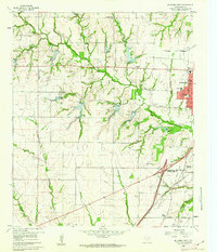
 1961 Anna1963 Print · USGSCollin County's agricultural and railroad landscapes are frozen in time here just as the early sixties began. Genealogists and historians can trace family roots through several rural burial sites like Melissa Cem and Highland Cem or locate the Independent Sch and early infrastructure like the Old Telephone Road.3 unique versions available
 - 1969 Map of Frisco
 1969 Frisco1969 Print · USGSThe North Texas prairie comes into focus during the late sixties as the rail-driven towns of Frisco and Prosper begin to grow. Genealogists can locate family burial sites like Bethel Cem and Landrum Cem nestled among traditional farm fields.
End of results
Showing maps 1-6 of 6
Top cities near McKinney
- Dallas historical maps
- Plano historical maps
- Frisco historical maps
- Carrollton historical maps
- Richardson historical maps
- Allen historical maps
See more
Top neighborhoods of McKinney
Frequently asked questions
- What are the different types of historical maps available for McKinney?
- What is the oldest map of McKinney?
- Where can I purchase historical maps of McKinney for my home or office?
- Where can I download high-res historical maps of McKinney?
- Are there historical topographic maps available for McKinney?
- Is there historical aerial imagery available for McKinney?
- Where are historical maps of McKinney sourced from?