1920s Maps of Comal County, Texas
Explore 8 historic maps of Comal County from the 1920s. These maps offer a rare glimpse into what life looked like during the 1920s — showing old roads, neighborhoods, homes, and landmarks that have changed or disappeared over time.
Whether you're researching your family's past, planning a metal detecting trip, or studying how Comal County's landscape evolved across the 1920s, these high-resolution maps are a powerful tool for exploring the history of this region.
- Focus on a specific era: All maps on this page are from the 1920s, giving you a focused view of this time period.
- See what’s changed: Compare century-old streets, trails, and buildings to today's modern landscape using overlays and satellite layers.
- Research with precision: Use these maps for genealogy, historical research, land use analysis, or educational projects.
- View, download, or print: Maps are fully viewable online in high resolution, and can be downloaded or printed for your own records.
Start exploring Comal County's history through authentic maps from the 1920s. This is your window into the past.
Comal County, TX maps
(8)- 1920 Map of Smithsons Valley
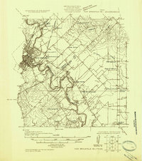
 1920 Smithsons Valley1920 Print · USGSThe Texas Hill Country comes alive in this 1920s-era survey of the Guadalupe River valley. Genealogists and local historians can trace early family outposts and commerce at Fischers Store, Cranes Mill, and Wesson P.O.
 - 1925 Map of New Braunfels No 1
 1925 New Braunfels No 11925 Print · USGSCentral Texas farming communities thrive along the river as the mid-twenties approach. Researchers can trace rural lineages through numerous country schoolhouses like Austin Hill School and local landmarks such as HORTONTOWN CEMETERY and Gruene.
 - 1925 Map of Hunter No 3
 1925 Hunter No 31925 Print · USGSThe Comal County backcountry comes into focus during the mid-twenties as the Guadalupe River winds through a complex network of creeks. Researchers can locate early homesteading landmarks such as Sattler, Fischer Store, and the route of the Blanco New Braunfels Road.
 - 1925 Map of Smithson Valley No. 1
 1925 Smithson Valley No. 11925 Print · USGSTexas Hill Country life in the mid-twenties centers on the meandering Guadalupe River valley before major modern alterations. Genealogists and local historians can trace legacy sites like Fischer Store, Cranes Mill, and the Rebecca Creek School.
 - 1927 Map of New Braunfels
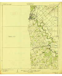 1927 New Braunfels1927 Print · USGSNew Braunfels and the surrounding river valleys are captured here during the mid-twenties, when the regional rail and school networks were at their peak. Genealogists and historians can trace family locations near landmarks like Gaudalupe College, Hortontown Cemetery, and dozens of rural schoolhouses like Austin Hill School.3 unique versions available
 - 1927 Map of Smithson Valley
 1927 Smithson Valley1927 Print · USGSThe Texas Hill Country comes to life in the mid-1920s, showing the Guadalupe River valley decades before it was altered by Canyon Lake. Researchers can trace rural landmarks like Fischer Store, the Rebecca Creek School, and Cranes Mill.
 - 1929 Map of Hunter
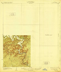 1929 Hunter1929 Print · USGSComal County was a landscape of deep limestone valleys and winding river bends in the late twenties. Genealogists and local historians can trace the early layout of Sattler or locate family landmarks near Waco Spring and Mountain Creek.2 unique versions available
 - 1929 Map of Smithson Valley, 1958 Print
 1929 Smithson Valley1958 Print · USGSCentral Texas Hill Country life in the late 1920s centered on the river and the road. Genealogists can trace early homesteads near Fischer Store, Anhalt, and rural schoolhouses like Smithson Valley School.
End of results
Showing maps 1-8 of 8
Top cities of Comal County
Frequently asked questions
- What are the different types of historical maps available for Comal County?
- What is the oldest map of Comal County?
- Where can I purchase historical maps of Comal County for my home or office?
- Where can I download high-res historical maps of Comal County?
- Are there historical topographic maps available for Comal County?
- Is there historical aerial imagery available for Comal County?
- Where are historical maps of Comal County sourced from?