1960s Maps of Comal County, Texas
Explore 18 historic maps of Comal County from the 1960s. These maps offer a rare glimpse into what life looked like during the 1960s — showing old roads, neighborhoods, homes, and landmarks that have changed or disappeared over time.
Whether you're researching your family's past, planning a metal detecting trip, or studying how Comal County's landscape evolved across the 1960s, these high-resolution maps are a powerful tool for exploring the history of this region.
- Focus on a specific era: All maps on this page are from the 1960s, giving you a focused view of this time period.
- See what’s changed: Compare century-old streets, trails, and buildings to today's modern landscape using overlays and satellite layers.
- Research with precision: Use these maps for genealogy, historical research, land use analysis, or educational projects.
- View, download, or print: Maps are fully viewable online in high resolution, and can be downloaded or printed for your own records.
Start exploring Comal County's history through authentic maps from the 1960s. This is your window into the past.
Comal County, TX maps
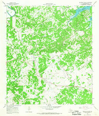
(18)- 1963 Map of Rough Hollow, 1965 Print
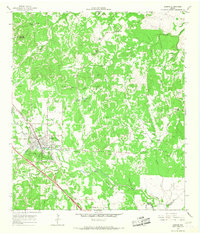
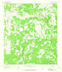 1963 Rough Hollow1965 Print · USGSThe Texas Hill Country comes alive in this early 1960s survey of the Blanco River valley. Trace family history at Mt Sharp Cem or locate the artesian flow of Jacobs Well (Flowing) and the historic Pleasant Valley Crossing.3 unique versions available
 - 1963 Map of Payton, 1965 Print
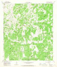
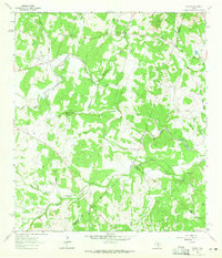 1963 Payton1965 Print · USGSIn the early sixties, the Texas Hill Country around the Blanco River remained a landscape of quiet rural communities and perennial springs. Researchers can trace the civic heart of Payton through its Payton Sch, Payton Cem, and the unique topography of The Narrows.3 unique versions available
 - 1963 Map of Sattler, 1965 Print
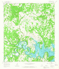
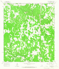
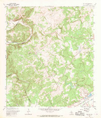
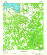 1963 Sattler1965 Print · USGSThe Comal County backcountry underwent a massive transformation in the early sixties as the Canyon Reservoir was established along the Guadalupe River. Researchers can trace the legacy of local settlements like Sattler and Canyon City, or locate specific landmarks like the Mountain Valley Sch and Slumber Falls.4 unique versions available
 - 1963 Map of Devils Backbone, 1965 Print
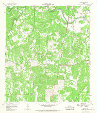
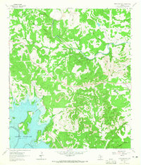 1963 Devils Backbone1965 Print · USGSThe Comal and Hays county line near the Guadalupe River is shown here in the early sixties, just as the basin began filling. Researchers can locate family landmarks like Valley Ford Cemetery, El Rancho Cima, and the ridge road along the Devils Backbone.3 unique versions available
 - 1963 Map of Fischer, 1967 Print
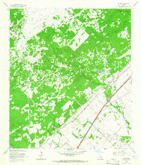
 1963 Fischer1967 Print · USGSComal County's river-cut landscape was undergoing a major transformation in the early sixties as the Guadalupe valley began to fill with water. Researchers can trace family sites like Bremer Cem and early settlements at Fischer and Cranes Mill before the lake reshaped the region.2 unique versions available
 - 1964 Map of Hunter, 1965 Print
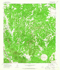
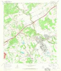
 1964 Hunter1965 Print · USGSMid-century Comal County is characterized by a dense network of family cemeteries and dual-rail transit through the settlement of Hunter. Researchers can locate historic rural burial grounds like Rosenthal Cem and trace the paths of the Missouri Pacific and Missouri Kansas Texas lines.5 unique versions available
 - 1964 Map of San Marcos South, 1966 Print
 1964 San Marcos South1966 Print · USGSThe rural hills south of San Marcos were defined by a junction of major railroads and creek-fed farms in the mid-1960s. Researchers can trace family history through sites like Pitts Cemetery or locate old school sites like Bowie School near Centerpoint.3 unique versions available
 - 1964 Map of Wimberley, 1966 Print
 1964 Wimberley1966 Print · USGSThe Wimberley area of the Texas Hill Country comes into focus during the mid-1960s, showing a landscape defined by the Blanco River and ranching heritage. Researchers can trace family-named lands like Freeman Ranch and Scrutchin Ranch or locate the early layout of Pioneer Town.2 unique versions available
 - 1964 Map of Boerne, 1967 Print
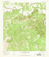
 1964 Boerne1967 Print · USGSMid-century Boerne serves as the anchor for this 1960s Hill Country survey as the town begins to expand around its historic rail line. Researchers can locate family landmarks like Phillips Cem, the Herff Park Fairground, and the subterranean Cascade Cavern.4 unique versions available
 - 1964 Map of Bergheim, 1967 Print
 1964 Bergheim1967 Print · USGSThe Texas Hill Country at the intersection of Kendall and Comal counties is captured here in the mid-1960s as rural crossroads began to evolve. Researchers can locate several family burial sites including Willke Cem and Honey Creek Cem, or trace the winding course of Cibolo Creek.2 unique versions available
 - 1964 Map of Spring Branch, 1967 Print
 1964 Spring Branch1967 Print · USGSTexas hill country life in the mid-1960s is centered here on the Guadalupe River and the settlement of Spring Branch. You can trace rural landmarks from the Spring Branch PO to the Twin Sisters peaks and the small community of Knibbe.2 unique versions available
 - 1964 Map of Anhalt, 1968 Print
 1964 Anhalt1968 Print · USGSComal County rural life in the mid-1960s is preserved here, showing the Texas Hill Country's network of family homesteads and local creeks. Genealogists can trace family lines through sites like Beierle Cem, St Joseph Chapel, and Farmers Hall.3 unique versions available
 - 1964 Map of Smithson Valley, 1968 Print
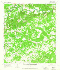
 1964 Smithson Valley1968 Print · USGSHill country life and the rising waters of the new reservoir define this Comal County survey from the mid-sixties. Genealogists can locate family-named sites like Jonas Cem and Heimer Cem, or trace the early development of Startzville and Smithson Valley.3 unique versions available
 - 1965 Map of Camp Bullis, 1966 Print
 1965 Camp Bullis1966 Print · USGSBexar County was a hub of military training in the mid-1960s, defined by the expansive Leon Springs Military Reservation. Researchers can trace the Government Railroad and locate family landmarks like the Goforth Cem or Schasse Hill.2 unique versions available
 - 1967 Map of Bulverde, 1969 Print
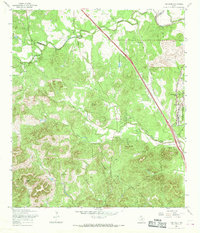
 1967 Bulverde1969 Print · USGSThe Texas Hill Country at the Comal and Bexar County border remains a landscape of family-named landmarks and rural outposts in the late sixties. Genealogists and local historians can locate numerous family burial sites like Weidner Cem and Koch Cem or trace the early paths of Specht Road and Bulverde Road.2 unique versions available
 - 1967 Map of Van Raub, 1969 Print
 1967 Van Raub1969 Print · USGSBexar County's Hill Country transition comes into focus in the late 1960s as suburban growth began to meet historic ranchlands. Researchers can trace the Southern Pacific rail line, old school sites at Leon Springs, and family burial grounds like Robles Cem.3 unique versions available
 - 1967 Map of Bat Cave, 1969 Print
 1967 Bat Cave1969 Print · USGSThe Comal County hill country comes to life in the late 1960s, showing the intersection of rail history and natural wonders. Genealogists can locate family sites like Hillert Cem and Kruetler Cem near the rail junction at Ogden.2 unique versions available
 - 1967 Map of Schertz, 1970 Print
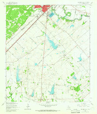
 1967 Schertz1970 Print · USGSBexar and Guadalupe counties are captured in a period of rapid suburban growth in the late sixties. Genealogists can trace family names at Davenport Cem and Wheeler Cem while exploring the layout of Randolph Air Force Base.2 unique versions available
End of results
Showing maps 1-18 of 18
Top cities of Comal County
Frequently asked questions
- What are the different types of historical maps available for Comal County?
- What is the oldest map of Comal County?
- Where can I purchase historical maps of Comal County for my home or office?
- Where can I download high-res historical maps of Comal County?
- Are there historical topographic maps available for Comal County?
- Is there historical aerial imagery available for Comal County?
- Where are historical maps of Comal County sourced from?