1980s Maps of Lowake, Texas
Explore 2 historic maps of Lowake from the 1980s. These maps offer a rare glimpse into what life looked like during the 1980s — showing old roads, neighborhoods, homes, and landmarks that have changed or disappeared over time.
Whether you're researching your family's past, planning a metal detecting trip, or studying how Lowake's landscape evolved across the 1980s, these high-resolution maps are a powerful tool for exploring the history of this region.
- Focus on a specific era: All maps on this page are from the 1980s, giving you a focused view of this time period.
- See what’s changed: Compare century-old streets, trails, and buildings to today's modern landscape using overlays and satellite layers.
- Research with precision: Use these maps for genealogy, historical research, land use analysis, or educational projects.
- View, download, or print: Maps are fully viewable online in high resolution, and can be downloaded or printed for your own records.
Start exploring Lowake's history through authentic maps from the 1980s. This is your window into the past.
Lowake, TX maps
(2)- 1984 Map of Lowake
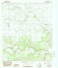 1984 Lowake1984 Print · USGSThe tri-county junction of Tom Green, Runnels, and Concho Counties is captured here in the mid-1980s. Researchers can trace the rural landscape of Lowake and find specific landmarks like the Coline Marker, Chandler Lake, and agricultural Storage Bins.
 - 1986 Map of Robert Lee
 1986 Robert Lee1986 Print · USGSWest Texas ranching and oil country come into focus in the mid-eighties as the E V Spence Reservoir reshapes the landscape near Robert Lee. Researchers can trace the path of the Atchison Topeka and Santa Fe railroad through Rowena or locate the historic Fort Chadbourne.2 unique versions available
End of results
Showing maps 1-2 of 2
Top cities near Lowake
Frequently asked questions
- What are the different types of historical maps available for Lowake?
- What is the oldest map of Lowake?
- Where can I purchase historical maps of Lowake for my home or office?
- Where can I download high-res historical maps of Lowake?
- Are there historical topographic maps available for Lowake?
- Is there historical aerial imagery available for Lowake?
- Where are historical maps of Lowake sourced from?