1990s Maps of Gatesville, Texas
Explore 2 historic maps of Gatesville from the 1990s. These maps offer a rare glimpse into what life looked like during the 1990s — showing old roads, neighborhoods, homes, and landmarks that have changed or disappeared over time.
Whether you're researching your family's past, planning a metal detecting trip, or studying how Gatesville's landscape evolved across the 1990s, these high-resolution maps are a powerful tool for exploring the history of this region.
- Focus on a specific era: All maps on this page are from the 1990s, giving you a focused view of this time period.
- See what’s changed: Compare century-old streets, trails, and buildings to today's modern landscape using overlays and satellite layers.
- Research with precision: Use these maps for genealogy, historical research, land use analysis, or educational projects.
- View, download, or print: Maps are fully viewable online in high resolution, and can be downloaded or printed for your own records.
Start exploring Gatesville's history through authentic maps from the 1990s. This is your window into the past.
Gatesville, TX maps
(2)- 1994 Map of Gatesville East, 1995 Print
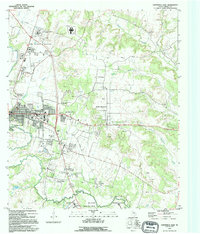 1994 Gatesville East1995 Print · USGSCoryell County during the mid-nineties shows the distinct intersection of civic life in GATESVILLE and the massive FORT HOOD MILITARY RESERVATION. Local historians can trace family plots at Restland Cem and Oak Grove Cem, or locate the Historical Marker Fort Gates near the river.
 - 1995 Map of Gatesville West
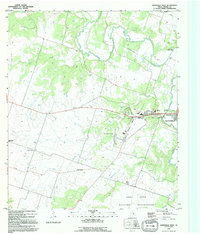 1995 Gatesville West1995 Print · USGSCoryell County during the mid-nineties shows the western growth of the county seat alongside major military and state institutions. Genealogists and local historians can locate Hermeline Cem, Standifer Chapel, and the Old Railroad Grade near the Leon River.
End of results
Showing maps 1-2 of 2
Top cities near Gatesville
Top neighborhoods of Gatesville
Frequently asked questions
- What are the different types of historical maps available for Gatesville?
- What is the oldest map of Gatesville?
- Where can I purchase historical maps of Gatesville for my home or office?
- Where can I download high-res historical maps of Gatesville?
- Are there historical topographic maps available for Gatesville?
- Is there historical aerial imagery available for Gatesville?
- Where are historical maps of Gatesville sourced from?