1990s Maps of Irving, Texas
Explore 2 historic maps of Irving from the 1990s. These maps offer a rare glimpse into what life looked like during the 1990s — showing old roads, neighborhoods, homes, and landmarks that have changed or disappeared over time.
Whether you're researching your family's past, planning a metal detecting trip, or studying how Irving's landscape evolved across the 1990s, these high-resolution maps are a powerful tool for exploring the history of this region.
- Focus on a specific era: All maps on this page are from the 1990s, giving you a focused view of this time period.
- See what’s changed: Compare century-old streets, trails, and buildings to today's modern landscape using overlays and satellite layers.
- Research with precision: Use these maps for genealogy, historical research, land use analysis, or educational projects.
- View, download, or print: Maps are fully viewable online in high resolution, and can be downloaded or printed for your own records.
Start exploring Irving's history through authentic maps from the 1990s. This is your window into the past.
Irving, TX maps
(2)- 1995 Map of Irving, 2002 Print
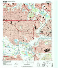 1995 Irving2002 Print · USGSIrving and West Dallas are shown in the mid-1990s, capturing the area's transition from a rail-and-quarry industrial hub to a dense suburban center. Researchers can trace historic sites like Sowers Cem, the Cistercian Monastery, and the footprint of Texas Stadium.
 - 1995 Map of Euless, 2002 Print
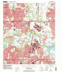 1995 Euless2002 Print · USGSMid-Cities development in the mid-nineties shows the urban interface between the burgeoning Dallas - Fort Worth International Airport and the surrounding suburbs. Researchers can locate long-standing local landmarks like Bear Creek Cem and Mt Elam Ch amid the modern growth of Euless and Irving.
End of results
Showing maps 1-2 of 2
Top cities near Irving
- Dallas historical maps
- Fort Worth historical maps
- Arlington historical maps
- Plano historical maps
- Frisco historical maps
- Grand Prairie historical maps
See more
Top neighborhoods of Irving
- Estelle historical maps
- Las Colinas historical maps
- Valley Ranch historical maps
- Williams Square Park historical maps
Frequently asked questions
- What are the different types of historical maps available for Irving?
- What is the oldest map of Irving?
- Where can I purchase historical maps of Irving for my home or office?
- Where can I download high-res historical maps of Irving?
- Are there historical topographic maps available for Irving?
- Is there historical aerial imagery available for Irving?
- Where are historical maps of Irving sourced from?