1960s Maps of Argyle, Texas
Explore 2 historic maps of Argyle from the 1960s. These maps offer a rare glimpse into what life looked like during the 1960s — showing old roads, neighborhoods, homes, and landmarks that have changed or disappeared over time.
Whether you're researching your family's past, planning a metal detecting trip, or studying how Argyle's landscape evolved across the 1960s, these high-resolution maps are a powerful tool for exploring the history of this region.
- Focus on a specific era: All maps on this page are from the 1960s, giving you a focused view of this time period.
- See what’s changed: Compare century-old streets, trails, and buildings to today's modern landscape using overlays and satellite layers.
- Research with precision: Use these maps for genealogy, historical research, land use analysis, or educational projects.
- View, download, or print: Maps are fully viewable online in high resolution, and can be downloaded or printed for your own records.
Start exploring Argyle's history through authentic maps from the 1960s. This is your window into the past.
Argyle, TX maps
(2)- 1960 Map of Argyle, 1961 Print
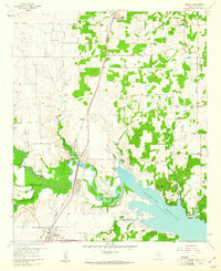 1960 Argyle1961 Print · USGSDenton County at the dawn of the 1960s shows a landscape transformed by the newly formed Grapevine Reservoir. Genealogists and historians can trace the early footprints of Argyle and Roanoke, locate the Double Oak Sch, or find industrial roots at the local Strip Mine.5 unique versions available
 - 1960 Map of Denton West, 1962 Print
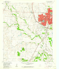 1960 Denton West1962 Print · USGSDenton's western edge in the early sixties showcases a growing university town bounded by rural research stations and sprawling cattle country. Researchers can trace the mid-century footprints of North Texas State College or locate the IOOF Cem and Roselawn Memorial Cem.4 unique versions available
End of results
Showing maps 1-2 of 2
Top cities near Argyle
- Dallas historical maps
- Fort Worth historical maps
- Irving historical maps
- Denton historical maps
- Lewisville historical maps
- Flower Mound historical maps
See more
Frequently asked questions
- What are the different types of historical maps available for Argyle?
- What is the oldest map of Argyle?
- Where can I purchase historical maps of Argyle for my home or office?
- Where can I download high-res historical maps of Argyle?
- Are there historical topographic maps available for Argyle?
- Is there historical aerial imagery available for Argyle?
- Where are historical maps of Argyle sourced from?