1960s Maps of Cross Roads, Texas
Explore 5 historic maps of Cross Roads from the 1960s. These maps offer a rare glimpse into what life looked like during the 1960s — showing old roads, neighborhoods, homes, and landmarks that have changed or disappeared over time.
Whether you're researching your family's past, planning a metal detecting trip, or studying how Cross Roads's landscape evolved across the 1960s, these high-resolution maps are a powerful tool for exploring the history of this region.
- Focus on a specific era: All maps on this page are from the 1960s, giving you a focused view of this time period.
- See what’s changed: Compare century-old streets, trails, and buildings to today's modern landscape using overlays and satellite layers.
- Research with precision: Use these maps for genealogy, historical research, land use analysis, or educational projects.
- View, download, or print: Maps are fully viewable online in high resolution, and can be downloaded or printed for your own records.
Start exploring Cross Roads's history through authentic maps from the 1960s. This is your window into the past.
Cross Roads, TX maps
(5)- 1960 Map of Green Valley, 1961 Print
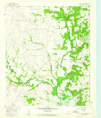 1960 Green Valley1961 Print · USGSDenton County at the start of the sixties reveals a landscape shaped by the Elm Fork of the Trinity River and the rising Garza-Little Elm Reservoir. Genealogists and historians can trace rural landmarks including Rock Hill Ch, Davis Cem, and the tracks of the Texas and Pacific railroad.4 unique versions available
 - 1960 Map of Aubrey, 1962 Print
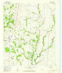 1960 Aubrey1962 Print · USGSDenton County agricultural life is captured here in the early sixties, just as the Garza-Little Elm Reservoir began to reshape the local geography. Researchers can pinpoint the Belew Cem, the central Aubrey townsite, and rural landmarks like the Community House.2 unique versions available
 - 1960 Map of Denton East, 1962 Print
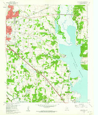 1960 Denton East1962 Print · USGSDenton County in the early sixties captures a transition from college-town growth to the lakeside developments of Lake Dallas. Genealogists can trace family names at Oakwood Cem and Swisher Cem, or locate the historic Old Alton Ch.5 unique versions available
 - 1960 Map of Little Elm, 1962 Print
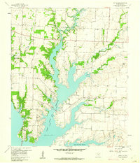 1960 Little Elm1962 Print · USGSDenton County was in the midst of a transformation at the start of the sixties as the Garza-Little Elm Reservoir reshaped the land. Researchers can trace family history at Little Elm Cemetery or locate landmarks like Mary Young Chapel and the small community of Navo.2 unique versions available
 - 1969 Map of Little Elm
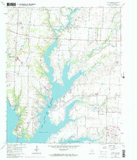 1969 Little Elm1969 Print · USGSThe Denton County countryside undergoes a major transformation in the late sixties as reservoir waters reshape the landscape. Genealogists and historians can trace family plots at Little Elm Cem and Lloyd Cem or locate old community centers like Navo.
End of results
Showing maps 1-5 of 5
Top cities near Cross Roads
- Dallas historical maps
- Fort Worth historical maps
- Plano historical maps
- Frisco historical maps
- Carrollton historical maps
- Denton historical maps
See more
Top neighborhoods of Cross Roads
Frequently asked questions
- What are the different types of historical maps available for Cross Roads?
- What is the oldest map of Cross Roads?
- Where can I purchase historical maps of Cross Roads for my home or office?
- Where can I download high-res historical maps of Cross Roads?
- Are there historical topographic maps available for Cross Roads?
- Is there historical aerial imagery available for Cross Roads?
- Where are historical maps of Cross Roads sourced from?