1980s Maps of Hickory Creek, Texas
Explore 2 historic maps of Hickory Creek from the 1980s. These maps offer a rare glimpse into what life looked like during the 1980s — showing old roads, neighborhoods, homes, and landmarks that have changed or disappeared over time.
Whether you're researching your family's past, planning a metal detecting trip, or studying how Hickory Creek's landscape evolved across the 1980s, these high-resolution maps are a powerful tool for exploring the history of this region.
- Focus on a specific era: All maps on this page are from the 1980s, giving you a focused view of this time period.
- See what’s changed: Compare century-old streets, trails, and buildings to today's modern landscape using overlays and satellite layers.
- Research with precision: Use these maps for genealogy, historical research, land use analysis, or educational projects.
- View, download, or print: Maps are fully viewable online in high resolution, and can be downloaded or printed for your own records.
Start exploring Hickory Creek's history through authentic maps from the 1980s. This is your window into the past.
Hickory Creek, TX maps
(2)- 1985 Map of McKinney
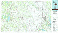
 1985 McKinney1985 Print · USGSNorth Texas in the mid-1980s was a landscape of rural communities connected by a complex web of railroads and creek systems. Researchers can trace family roots through settlements like Westminster, find local landmarks like Henslee Chapel, or map the industrial activity at various Gravel Pits.2 unique versions available
 - 1985 Map of Denton
 1985 Denton1985 Print · USGSNorth Texas in the mid-eighties shows a region of growing towns and established rail lines. Trace family roots and local history through Wizard Wells, the old Oaklawn Cem, and the tracks of the Burlington Northern.
End of results
Showing maps 1-2 of 2
Top cities near Hickory Creek
- Dallas historical maps
- Fort Worth historical maps
- Plano historical maps
- Irving historical maps
- Frisco historical maps
- Carrollton historical maps
See more
Top neighborhoods of Hickory Creek
Frequently asked questions
- What are the different types of historical maps available for Hickory Creek?
- What is the oldest map of Hickory Creek?
- Where can I purchase historical maps of Hickory Creek for my home or office?
- Where can I download high-res historical maps of Hickory Creek?
- Are there historical topographic maps available for Hickory Creek?
- Is there historical aerial imagery available for Hickory Creek?
- Where are historical maps of Hickory Creek sourced from?