1980s Maps of Dickens County, Texas
Explore 4 historic maps of Dickens County from the 1980s. These maps offer a rare glimpse into what life looked like during the 1980s — showing old roads, neighborhoods, homes, and landmarks that have changed or disappeared over time.
Whether you're researching your family's past, planning a metal detecting trip, or studying how Dickens County's landscape evolved across the 1980s, these high-resolution maps are a powerful tool for exploring the history of this region.
- Focus on a specific era: All maps on this page are from the 1980s, giving you a focused view of this time period.
- See what’s changed: Compare century-old streets, trails, and buildings to today's modern landscape using overlays and satellite layers.
- Research with precision: Use these maps for genealogy, historical research, land use analysis, or educational projects.
- View, download, or print: Maps are fully viewable online in high resolution, and can be downloaded or printed for your own records.
Start exploring Dickens County's history through authentic maps from the 1980s. This is your window into the past.
Dickens County, TX maps
(4)- 1985 Map of Dickens
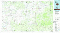 1985 Dickens1985 Print · USGSThe West Texas ranchlands near the Dickens and King County lines are shown here in the mid-eighties as a network of rural settlements and canyon terrain. Trace family roots or land boundaries near Roaring Springs, Soldier Mound, or the Fort Worth and Denver Railroad.2 unique versions available
 - 1985 Map of Aspermont, 1994 Print
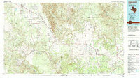 1985 Aspermont1994 Print · USGSStonewall and Kent counties are shown in the mid-1980s as the river-cut plains of West Texas supported scattered ranching and oil communities. Genealogists and historians can trace the Railroad Grade and locate smaller locales like Old Glory and Girard.
 - 1986 Map of Slaton
 1986 Slaton1986 Print · USGSThe Llano Estacado meets the rolling breaks of the Brazos River in the mid-1980s as the region's ranching and rail roots remain visible. Trace the path of the Atchison Topeka and Santa Fe through Post or locate Guthrie Lake and Wilson.2 unique versions available
 - 1986 Map of Lubbock
 1986 Lubbock1986 Print · USGSLubbock and the surrounding High Plains are documented in the mid-eighties as a structured grid of agricultural tracts and growing urban centers. Genealogists and local historians can trace family-named areas like Heckville, old rail stops on the Atchison Topeka and Santa Fe, and the winding path of Yellow House Canyon.2 unique versions available
End of results
Showing maps 1-4 of 4
Top cities of Dickens County
Frequently asked questions
- What are the different types of historical maps available for Dickens County?
- What is the oldest map of Dickens County?
- Where can I purchase historical maps of Dickens County for my home or office?
- Where can I download high-res historical maps of Dickens County?
- Are there historical topographic maps available for Dickens County?
- Is there historical aerial imagery available for Dickens County?
- Where are historical maps of Dickens County sourced from?