1940s Maps of Edwards County, Texas
Explore 6 historic maps of Edwards County from the 1940s. These maps offer a rare glimpse into what life looked like during the 1940s — showing old roads, neighborhoods, homes, and landmarks that have changed or disappeared over time.
Whether you're researching your family's past, planning a metal detecting trip, or studying how Edwards County's landscape evolved across the 1940s, these high-resolution maps are a powerful tool for exploring the history of this region.
- Focus on a specific era: All maps on this page are from the 1940s, giving you a focused view of this time period.
- See what’s changed: Compare century-old streets, trails, and buildings to today's modern landscape using overlays and satellite layers.
- Research with precision: Use these maps for genealogy, historical research, land use analysis, or educational projects.
- View, download, or print: Maps are fully viewable online in high resolution, and can be downloaded or printed for your own records.
Start exploring Edwards County's history through authentic maps from the 1940s. This is your window into the past.
Edwards County, TX maps
(6)- 1943 Map of Carta Valley
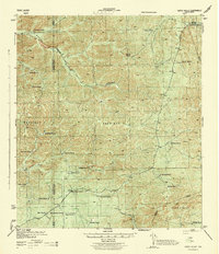 1943 Carta Valley1943 Print · USGSTexas ranching culture is preserved in this wartime survey of the Edwards Plateau. Researchers can trace historic family holdings across the landscape, from Carta Valley to remote outposts like Wittenburg Ranch, Camp Brown Ranch, and Galloway Ranch.
 - 1944 Map of Barksdale
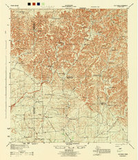
 1944 Barksdale1944 Print · USGSThe Edwards County ranching country of the mid-1940s is detailed here during the expansion of rural utility lines and cattle operations. Genealogists can locate family-named landmarks like Double Wells Ranch, Old Chapman Place, and the riverfront grounds of Camp Wood.
 - 1944 Map of Flat Rock
 1944 Flat Rock1944 Print · USGSRanching life on the Edwards Plateau is captured during the mid-1940s, showing a landscape defined by seasonal creek forks and family-owned lands. Researchers can trace historic property boundaries and water sources like the Thurman Well, Askew Ranch, and Hayes Ranch.
 - 1944 Map of Indian Creek
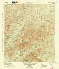 1944 Indian Creek1944 Print · USGSEdwards County ranching culture is preserved here during the mid-1940s, showing a landscape defined by water and wide-open range. Researchers can trace historic family boundaries and water sources like the Shreiner Ranch, Kickapoo Spring, and the Nueces River.
 - 1944 Map of Indian Mountain
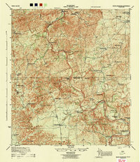 1944 Indian Mountain1944 Print · USGSThe ranchlands of the Edwards Plateau are frozen in time during the 1940s, where the Nueces River winds through high hills and deep draws. Genealogists and historians can trace legacy family holdings like Covington Ranch, Seargeant Ranch, and McNealy Ranch across the county lines.
 - 1947 Map of Hackberry, 1973 Print
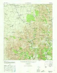 1947 Hackberry1973 Print · USGSRanching life in the Edwards Plateau is captured here just after the war. Family historians can trace ancestral holdings like Wittenburg Ranch and Hampton Ranch, or locate the rural Cedar Creek School.
End of results
Showing maps 1-6 of 6
Top cities of Edwards County
Frequently asked questions
- What are the different types of historical maps available for Edwards County?
- What is the oldest map of Edwards County?
- Where can I purchase historical maps of Edwards County for my home or office?
- Where can I download high-res historical maps of Edwards County?
- Are there historical topographic maps available for Edwards County?
- Is there historical aerial imagery available for Edwards County?
- Where are historical maps of Edwards County sourced from?