1900s (20th Century) Maps of Rocksprings, Texas
Explore 5 historic maps of Rocksprings from the 1900s (20th Century). These maps offer a rare glimpse into what life looked like during the 1900s — showing old roads, neighborhoods, homes, and landmarks that have changed or disappeared over time.
Whether you're researching your family's past, planning a metal detecting trip, or studying how Rocksprings's landscape evolved across the 1900s, these high-resolution maps are a powerful tool for exploring the history of this region.
- Focus on a specific era: All maps on this page are from the 1900s, giving you a focused view of this time period.
- See what’s changed: Compare century-old streets, trails, and buildings to today's modern landscape using overlays and satellite layers.
- Research with precision: Use these maps for genealogy, historical research, land use analysis, or educational projects.
- View, download, or print: Maps are fully viewable online in high resolution, and can be downloaded or printed for your own records.
Start exploring Rocksprings's history through authentic maps from the 1900s. This is your window into the past.
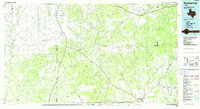
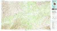
Rocksprings, TX maps
(5)- 1954 Map of Sonora, 1965 Print
 1954 Sonora1965 Print · USGSThe Edwards Plateau and West Texas ranching country come alive in this mid-century survey of the canyons and plateaus. Genealogists and historians can trace the remote settlements of Pandale and Loma Alta or follow the path of the Panhandle and Santa Fe RR.2 unique versions available
 - 1958 Map of Sonora
 1958 Sonora1958 Print · USGSThe Edwards Plateau and Trans-Pecos region come alive in the late fifties, showing a landscape of remote ranchlands and historic frontier outposts. Trace the legacy of Fort Lancaster Ruins, the limestone depths of Devils Sinkhole Cavern, and the path of the Pecos River.
 - 1971 Map of Rocksprings, 1973 Print
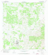 1971 Rocksprings1973 Print · USGSRocksprings and the surrounding Edwards County plateau are captured here in the early seventies, detailing the town's civic core and rural outskirts. Researchers can trace the town's development through the High Sch, Cem, and the site of Old Rock Springs.2 unique versions available
 - 1985 Map of Rocksprings, 1986 Print
 1985 Rocksprings1986 Print · USGSThe Edwards Plateau in the mid-1980s is captured here at the junction of four counties, centered on the settlement of Rocksprings. Geologists and local historians can trace the network of drainage draws and subterranean features like Felton Cave, Word Cave, and the path of the Devils River.
 - 1993 Map of Rocksprings
 1993 Rocksprings1993 Print · USGSThe Edwards Plateau ranching country is captured here in the early nineties, centered on the high-elevation hub of Rocksprings. Genealogists and local historians can trace the paths of the Old Spanish Road and the intricate draws like Tenmile Draw or Dragoo Hollow.
End of results
Showing maps 1-5 of 5
Frequently asked questions
- What are the different types of historical maps available for Rocksprings?
- What is the oldest map of Rocksprings?
- Where can I purchase historical maps of Rocksprings for my home or office?
- Where can I download high-res historical maps of Rocksprings?
- Are there historical topographic maps available for Rocksprings?
- Is there historical aerial imagery available for Rocksprings?
- Where are historical maps of Rocksprings sourced from?