1990s Maps of Desert Glen Colonia, Texas
Explore 1 historic maps of Desert Glen Colonia from the 1990s. These maps offer a rare glimpse into what life looked like during the 1990s — showing old roads, neighborhoods, homes, and landmarks that have changed or disappeared over time.
Whether you're researching your family's past, planning a metal detecting trip, or studying how Desert Glen Colonia's landscape evolved across the 1990s, these high-resolution maps are a powerful tool for exploring the history of this region.
- Focus on a specific era: All maps on this page are from the 1990s, giving you a focused view of this time period.
- See what’s changed: Compare century-old streets, trails, and buildings to today's modern landscape using overlays and satellite layers.
- Research with precision: Use these maps for genealogy, historical research, land use analysis, or educational projects.
- View, download, or print: Maps are fully viewable online in high resolution, and can be downloaded or printed for your own records.
Start exploring Desert Glen Colonia's history through authentic maps from the 1990s. This is your window into the past.
Desert Glen Colonia, TX maps
(1)- 1995 Map of Nations South Well
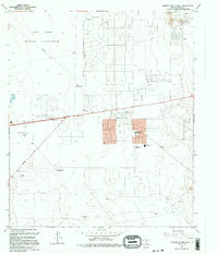 1995 Nations South Well1995 Print · USGSEl Paso's eastern desert fringes are captured in the mid-1990s as suburban residential grids began to meet the edges of the Fort Bliss Military Reservation. You can locate vanished landmarks like the Drive-in Theater and the Drag Strip, or trace old ranching locations at Rockhouse (Site).
End of results
Showing maps 1-1 of 1
Top cities near Desert Glen Colonia
- El Paso historical maps
- Socorro historical maps
- Horizon City historical maps
- San Elizario historical maps
- Clint historical maps
Frequently asked questions
- What are the different types of historical maps available for Desert Glen Colonia?
- What is the oldest map of Desert Glen Colonia?
- Where can I purchase historical maps of Desert Glen Colonia for my home or office?
- Where can I download high-res historical maps of Desert Glen Colonia?
- Are there historical topographic maps available for Desert Glen Colonia?
- Is there historical aerial imagery available for Desert Glen Colonia?
- Where are historical maps of Desert Glen Colonia sourced from?