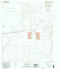
1995 Map of Nations South Well
USGS Topo · Published 1995About this map
Fort Bliss Military Reservation dominates the northern and western reaches of this East El Paso landscape, illustrating the significant military footprint on the Chihuahuan Desert. By the mid-1990s, the area shows a transition from historical ranching outposts to suburban expansion, with several former watering spots now identified as locations like Nations South Well (Site), Hueco Water Wells (Site), and Dagger Well (Site). The growth of the Montana Vista community is evident through the presence of Montana Vista Sch and Mountain View High Sch, alongside recreational markers like a Drive-in Theater and the Drag Strip. This map captures the intersection of desert infrastructure, including extensive Pipelines, and the emerging residential grid systems that began to define the outskirts of El Paso during this era.
Find a feature on this map
21 named features on this map. Tap any name to fly to it.
Don’t see what you’re looking for? This feature index may not catch every label — zoom into the map to look around manually.
Map Details
Editions of this 1995 Nations South Well Map
This is the sole edition of this map. No revisions or reprints were ever made.
Other maps of this area

1896 · El Paso
USGS Topo · 1:125,000

1908 · El Paso
USGS Topo · 1:125,000

1939 · Ysleta
USGS Topo · 1:62,500

1939 · Heuco Tanks
USGS Topo · 1:62,500

1940 · Heuco Tanks
USGS Topo · 1:62,500

1941 · Clint
USGS Topo · 1:62,500

1941 · Ysleta
USGS Topo · 1:62,500

1942 · Fort Bliss
USGS Topo · 1:62,500

1944 · Heuco Tanks
USGS Topo · 1:62,500

1945 · Ysleta
USGS Topo · 1:62,500
Featured Places
- El Paso, TX
- Deerfield Park Colonia, TX
- Homestead Meadows South Number 6 Colonia, TX
- McCracken Estates Colonia, TX
- Homestead Homes Colonia, TX