1941 Map of Clint
USGS Topo · Published 1941About this map
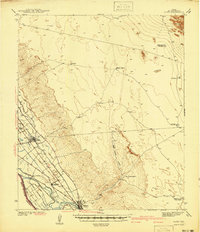
The Rio Grande valley southeast of El Paso serves as the agricultural and transportation heart of this 1939 survey. The intricate network of irrigation, including the Franklin Canal, San Elizario Main Canal, and Mesa Drain, illustrates the transformation of the desert floor into productive land around Clint and Fabens. Parallel tracks of the Southern Pacific and Texas and Pacific railroads dominate the corridor, highlighting the importance of rail transit to the regional economy. Beyond the valley, the landscape shifts abruptly to the arid Mesa and the striking Rimrock formation. To the northeast, the terrain is marked by isolated outposts like Roberts Ranch and Riddleman Well (Abandoned), alongside geological curiosities such as Moving Dunes. This map documents a period when rural ranching and intensive river-valley farming existed side-by-side on the San Elizario Island.
Find a feature on this map
35 named features on this map. Tap any name to fly to it.
Don’t see what you’re looking for? This feature index may not catch every label — zoom into the map to look around manually.
Map Details
Editions of this 1941 Clint Map
This is the sole edition of this map. No revisions or reprints were ever made.
Other maps of this area

1894 · Fort Hancock
USGS Topo · 1:125,000

1896 · El Paso
USGS Topo · 1:125,000
1896 · Rio Grande
USGS Topo · 1:125,000

1903 · Cerro Alto
USGS Topo · 1:125,000

1908 · El Paso
USGS Topo · 1:125,000

1939 · Ysleta
USGS Topo · 1:62,500

1939 · Heuco Tanks
USGS Topo · 1:62,500

1940 · Heuco Tanks
USGS Topo · 1:62,500

1941 · Ysleta
USGS Topo · 1:62,500
1941 · Tornillo
USGS Topo · 1:62,500