1940s Maps of Selfs, Texas
Explore 2 historic maps of Selfs from the 1940s. These maps offer a rare glimpse into what life looked like during the 1940s — showing old roads, neighborhoods, homes, and landmarks that have changed or disappeared over time.
Whether you're researching your family's past, planning a metal detecting trip, or studying how Selfs's landscape evolved across the 1940s, these high-resolution maps are a powerful tool for exploring the history of this region.
- Focus on a specific era: All maps on this page are from the 1940s, giving you a focused view of this time period.
- See what’s changed: Compare century-old streets, trails, and buildings to today's modern landscape using overlays and satellite layers.
- Research with precision: Use these maps for genealogy, historical research, land use analysis, or educational projects.
- View, download, or print: Maps are fully viewable online in high resolution, and can be downloaded or printed for your own records.
Start exploring Selfs's history through authentic maps from the 1940s. This is your window into the past.
Selfs, TX maps
(2)- 1947 Map of Honey Grove, 1966 Print
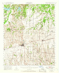 1947 Honey Grove1966 Print · USGSNortheast Texas at the close of the 1940s reveals a landscape of thriving rural school districts and rail-side commerce. Genealogists can trace family roots through numerous sites like McCraw Chapel, Oakwood Cem, and Michigan Prairie School.2 unique versions available
 - 1949 Map of Honey Grove
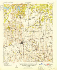 1949 Honey Grove1949 Print · USGSIn the late 1940s, the rural corridor between Honey Grove and Petty thrived as a network of rail-side towns and country schoolhouses. Genealogists can trace family landmarks like Spoonamore Hill, the Michigan Prairie School, and Oakwood Cem.
End of results
Showing maps 1-2 of 2
Top cities near Selfs
- Bonham historical maps
- Honey Grove historical maps
- Roxton historical maps
- Dodd City historical maps
- Windom historical maps
Frequently asked questions
- What are the different types of historical maps available for Selfs?
- What is the oldest map of Selfs?
- Where can I purchase historical maps of Selfs for my home or office?
- Where can I download high-res historical maps of Selfs?
- Are there historical topographic maps available for Selfs?
- Is there historical aerial imagery available for Selfs?
- Where are historical maps of Selfs sourced from?