1900s (20th Century) Maps of Ledbetter, Texas
Explore 4 historic maps of Ledbetter from the 1900s (20th Century). These maps offer a rare glimpse into what life looked like during the 1900s — showing old roads, neighborhoods, homes, and landmarks that have changed or disappeared over time.
Whether you're researching your family's past, planning a metal detecting trip, or studying how Ledbetter's landscape evolved across the 1900s, these high-resolution maps are a powerful tool for exploring the history of this region.
- Focus on a specific era: All maps on this page are from the 1900s, giving you a focused view of this time period.
- See what’s changed: Compare century-old streets, trails, and buildings to today's modern landscape using overlays and satellite layers.
- Research with precision: Use these maps for genealogy, historical research, land use analysis, or educational projects.
- View, download, or print: Maps are fully viewable online in high resolution, and can be downloaded or printed for your own records.
Start exploring Ledbetter's history through authentic maps from the 1900s. This is your window into the past.
Ledbetter, TX maps
(4)- 1919 Map of Giddings
 1919 Giddings1919 Print · USGSGiddings and the surrounding Lee County countryside are documented here at the end of the Great War era, when rail travel dominated the Texas interior. Local historians can trace the foundations of rural life through family-named landmarks like the Willy Branch School and numerous post offices including Northrup P.O. and Ledbetter P.O.
 - 1954 Map of Austin, 1964 Print
 1954 Austin1964 Print · USGSCentral Texas is captured during a period of steady growth as the capital city and its neighboring farm towns began to modernize. Researchers can trace historic rail corridors like the Southern Pacific RR or locate landmarks such as Bergstrom Air Force Base and Pilot Knob.4 unique versions available
 - 1958 Map of Ledbetter, 1959 Print
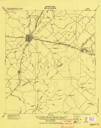
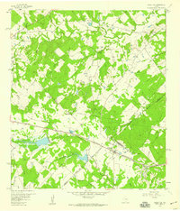 1958 Ledbetter1959 Print · USGSLedbetter and the surrounding cattle-and-rail country of Lee County are shown here in the late fifties. Genealogists and local historians can trace the foundations of Jones Colony, locate the Atkinson Cem, and follow the Texas and New Orleans railroad line.2 unique versions available
 - 1993 Map of Brenham
 1993 Brenham1993 Print · USGSTexas river country and the birthplace of the republic are showcased in the early nineties, centered on the confluence of the Brazos and Navasota. Researchers can trace the rail sidings of the Southern Pacific RR and locate historic community landmarks like St Paul Ch and Washington-on-the-Brazos State Park.
End of results
Showing maps 1-4 of 4
Top cities near Ledbetter
- Giddings historical maps
- La Grange historical maps
- Burton historical maps
- Carmine historical maps
- Round Top historical maps
Frequently asked questions
- What are the different types of historical maps available for Ledbetter?
- What is the oldest map of Ledbetter?
- Where can I purchase historical maps of Ledbetter for my home or office?
- Where can I download high-res historical maps of Ledbetter?
- Are there historical topographic maps available for Ledbetter?
- Is there historical aerial imagery available for Ledbetter?
- Where are historical maps of Ledbetter sourced from?