1960s Maps of Garza County, Texas
Explore 24 historic maps of Garza County from the 1960s. These maps offer a rare glimpse into what life looked like during the 1960s — showing old roads, neighborhoods, homes, and landmarks that have changed or disappeared over time.
Whether you're researching your family's past, planning a metal detecting trip, or studying how Garza County's landscape evolved across the 1960s, these high-resolution maps are a powerful tool for exploring the history of this region.
- Focus on a specific era: All maps on this page are from the 1960s, giving you a focused view of this time period.
- See what’s changed: Compare century-old streets, trails, and buildings to today's modern landscape using overlays and satellite layers.
- Research with precision: Use these maps for genealogy, historical research, land use analysis, or educational projects.
- View, download, or print: Maps are fully viewable online in high resolution, and can be downloaded or printed for your own records.
Start exploring Garza County's history through authentic maps from the 1960s. This is your window into the past.
Garza County, TX maps
(24)- 1962 Map of Twomile Creek, 1963 Print
 1962 Twomile Creek1963 Print · USGSThe ranchlands along the Brazos and White Rivers are captured here in the early sixties, showing the isolated schoolhouses and cattle tanks of West Texas. Genealogists can locate Swenson Ranch and the Upper Red Mud Sch near the Salt Fork Brazos River.
 - 1962 Map of Smith Tank, 1963 Print
 1962 Smith Tank1963 Print · USGSThe High Plains of West Texas are captured here in the early sixties during a period of major hydrological change. Researchers can trace the new shoreline of the White River Reservoir and locate landmarks like the White River Dam and Smith Tank.2 unique versions available
 - 1965 Map of Southland, 1966 Print
 1965 Southland1966 Print · USGSMid-century Lynn and Garza counties are captured here during a period of significant oil production and rail activity. Genealogists and researchers can trace the roads connecting Southland and Hackberry or locate family sites near Resthaven Cem and Gordon.
 - 1965 Map of Slaton NE, 1966 Print
 1965 Slaton NE1966 Print · USGSThe West Texas caprock country comes into focus in the mid-1960s as the rail lines and ranch lands around Lubbock County were being mapped in detail. Genealogists and local historians can trace the tracks of the Atchison Topeka and Santa Fe and locate family-named landmarks like Wood Ranch or the Katy K Ranch.2 unique versions available
 - 1966 Map of Cap Rock, 1968 Print
 1966 Cap Rock1968 Print · USGSThe West Texas escarpment near the Crosby and Garza county line was a landscape of oil exploration and dramatic river breaks in the mid-1960s. Genealogists and historians can trace the Forbes Oil Field, the isolated Cap Rock settlement, and landmarks like Courthouse Mtn.
 - 1966 Map of Kalgary, 1968 Print
 1966 Kalgary1968 Print · USGSThe Crosby County line meets Garza County in the mid-1960s, a period when rural ranching and water infrastructure dominated the landscape. Genealogists and local historians can trace the remote settlement of Kalgary and follow the paths of McDonald Creek and the expansive Aqueduct.
 - 1966 Map of Canyon Valley, 1969 Print
 1966 Canyon Valley1969 Print · USGSThe West Texas Caprock breaks are captured here in the mid-1960s, showing the rugged transition from high plains to river bottom. Researchers can trace the Salt Fork Brazos River and find the rural settlement of Canyon Valley.
 - 1968 Map of South Dokegood Creek, 1971 Print
 1968 South Dokegood Creek1971 Print · USGSGarza County in the late 1960s reveals a landscape where the petroleum industry and rail lines intersect with the Brazos River. Trace the operations of the H D Oil Field and the rural settlements of Buenos and Huntley along the river's fork.
 - 1969 Map of Verbena, 1971 Print
 1969 Verbena1971 Print · USGSGarza County's canyon breaks and high plains meet in the late sixties at the headwaters of the Brazos. Researchers can trace the development of the Post Oil Field and the small settlement of Verbena among the draws of McDonald Creek.
 - 1969 Map of Cap Rock SE, 1971 Print
 1969 Cap Rock SE1971 Print · USGSGarza County at the close of the 1960s reveals a landscape of petroleum exploration and precise water management along the Salt Fork Brazos River. Researchers can trace industrial markers like Oil Wells and a long Aqueduct alongside small-scale landmarks such as a lone Grave.
 - 1969 Map of Cottonwood Creek, 1971 Print
 1969 Cottonwood Creek1971 Print · USGSRanching life on the Texas plains comes into focus in the late sixties as the Brazos River forks wind through Garza and Kent counties. Genealogists and historians can trace family-named sites like Beggs Ranch, the Schoolhouse Windmill, and the community of Kent.
 - 1969 Map of Gail NE, 1971 Print
 1969 Gail NE1971 Print · USGSBorden and Garza counties in the late sixties show a landscape defined by the oil industry and ranching along the Double Mountain Fork Brazos River. Genealogists and historians can locate the Miller Ranch and trace Pipeline corridors near Sand Creek.2 unique versions available
 - 1969 Map of Justiceburg SE, 1971 Print
 1969 Justiceburg SE1971 Print · USGSKent County was a center of intensive oil exploration in the late 1960s, defined by its rugged river breaks and energy industry. Researchers can trace the development of the Dorward Oil Field and Birdwell alongside the Double Mountain Fork Brazos River.
 - 1969 Map of Beal Hollow, 1971 Print
 1969 Beal Hollow1971 Print · USGSBorden and Garza counties at the close of the 1960s show a landscape shaped by petroleum and ranching. Trace mid-century infrastructure like the Pumping Sta and pipelines alongside family-named landmarks like Beal Hollow and White Tank.
 - 1969 Map of Fluvanna, 1971 Print
 1969 Fluvanna1971 Print · USGSFluvanna and the high plains of Scurry and Borden counties are captured here in the late sixties as the local oil industry flourished. Researchers can trace the legacy of the Atchison Topeka and Santa Fe and locate the Fluvanna Cem near the Old Railroad Grade.
 - 1969 Map of Indian Canyon NE, 1971 Print
 1969 Indian Canyon NE1971 Print · USGSThe High Plains plateau gives way to the deep canyon breaks of Borden and Garza counties in the late sixties. Trace the ranching landscape around Dennis Ranch or follow the paths of Bull Creek and Salt Draw past early oil wells.
 - 1969 Map of Justiceburg NW, 1972 Print
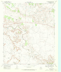 1969 Justiceburg NW1972 Print · USGSGarza County ranching and energy production are captured in high detail during the late 1960s. Researchers can locate specific water sources and family-named landmarks like the McCrary Ranch, Dick Woods Windmill, and Slicknasty Creek.
 - 1969 Map of Post East, 1972 Print
 1969 Post East1972 Print · USGSIn the late 1960s, Post, Texas, sat at the intersection of the High Plains and the developing West Texas oil patches. Researchers can trace the Atchison Topeka and Santa Fe rail line, the Terrace Cem, and family landmarks like the Cross H Ranch.
 - 1969 Map of Grassland SE, 1972 Print
 1969 Grassland SE1972 Print · USGSThe High Plains of West Texas meet the broken breaks of the Brazos River in the late sixties. Trace family land at Post Montgomery Ranch, locate the Grassland Cem, and follow the winding Dead Negro Draw.
 - 1969 Map of Justiceburg, 1972 Print
 1969 Justiceburg1972 Print · USGSJusticeburg and the surrounding Garza County oil fields are captured here during the late 1960s. Researchers can trace the ATCHISON TOPEKA AND SANTA FE rail corridor past the POST OIL FIELD and through the The Badlands.
 - 1969 Map of Post West, 1972 Print
 1969 Post West1972 Print · USGSThe Garza County landscape in the late sixties reveals the industrial and civic heart of Post as it sits along the Atchison Topeka and Santa Fe line. Researchers can locate family landmarks like Garza Memorial Hospital or trace the early development of Close City.
 - 1969 Map of Cooper Creek, 1972 Print
 1969 Cooper Creek1972 Print · USGSThe Garza County rangelands in the late sixties reveal a landscape of intensive oil exploration and vital water management. Trace the industrial footprint of the Garza Oil Field and Rocker A Oil Field alongside local landmarks like Two Bush Knob and Kelly Tank.
 - 1969 Map of Middle Creek, 1972 Print
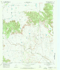 1969 Middle Creek1972 Print · USGSThe West Texas high plains of Garza County are captured in the late sixties, where the cattle industry met the growing oil patch. Researchers can trace the sprawling U Lazy S Ranch, find a remote Landing Strip, and follow the Double Mountain Fork Brazos River through the breaks.2 unique versions available
 - 1969 Map of Flat Top Mountain, 1972 Print
 1969 Flat Top Mountain1972 Print · USGSScurry County ranching and petroleum fields are shown here in the late sixties, where the railroad meets the rugged hills. You can trace family operations at Williams Ranch or locate rail stops along the Atchison Topeka and Santa Fe near Fullerville.
End of results
Showing maps 1-24 of 24
Top cities of Garza County
Frequently asked questions
- What are the different types of historical maps available for Garza County?
- What is the oldest map of Garza County?
- Where can I purchase historical maps of Garza County for my home or office?
- Where can I download high-res historical maps of Garza County?
- Are there historical topographic maps available for Garza County?
- Is there historical aerial imagery available for Garza County?
- Where are historical maps of Garza County sourced from?