1970s Maps of Goliad County, Texas
Explore 4 historic maps of Goliad County from the 1970s. These maps offer a rare glimpse into what life looked like during the 1970s — showing old roads, neighborhoods, homes, and landmarks that have changed or disappeared over time.
Whether you're researching your family's past, planning a metal detecting trip, or studying how Goliad County's landscape evolved across the 1970s, these high-resolution maps are a powerful tool for exploring the history of this region.
- Focus on a specific era: All maps on this page are from the 1970s, giving you a focused view of this time period.
- See what’s changed: Compare century-old streets, trails, and buildings to today's modern landscape using overlays and satellite layers.
- Research with precision: Use these maps for genealogy, historical research, land use analysis, or educational projects.
- View, download, or print: Maps are fully viewable online in high resolution, and can be downloaded or printed for your own records.
Start exploring Goliad County's history through authentic maps from the 1970s. This is your window into the past.
Goliad County, TX maps
(4)- 1978 Map of Ryanville, 1979 Print
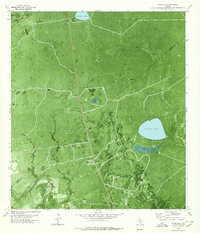 1978 Ryanville1979 Print · USGSThe South Texas brush country at the Goliad and Refugio county line comes into focus in the late 1970s, showing a landscape defined by ranching and oil. Researchers can trace the development of Ryanville and find local landmarks like Willow Lake, Roadside Park, and Ninemile Flat.
 - 1978 Map of Vidaurri, 1979 Print
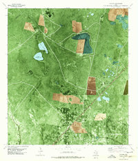 1978 Vidaurri1979 Print · USGSCoastal Texas ranching and energy production intersect in the late 1970s as the Missouri Pacific rail line connects small prairie outposts. Traces of the Tom O'Connor Oil Field and the Welder Ranch reveal the region's industrial and agricultural roots.
 - 1979 Map of Blanconia
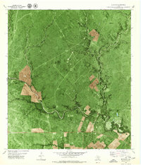 1979 Blanconia1979 Print · USGSDeep in South Texas during the late 1970s, this quadrangle shows the rural intersection of Goliad and Bee counties. Researchers can trace the development of the Blanconia Oil Field and locate landmarks like the local Cem and Blanconia settlement.
 - 1979 Map of Skidmore NE
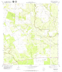 1979 Skidmore NE1979 Print · USGSCoastal plains ranch land along the Bee and Goliad county line is captured here in the late seventies. Family researchers can locate the Mucorrera Cemetery and trace the paths of Blanco Creek and Medio Creek across the territory.
End of results
Showing maps 1-4 of 4
Top cities of Goliad County
Frequently asked questions
- What are the different types of historical maps available for Goliad County?
- What is the oldest map of Goliad County?
- Where can I purchase historical maps of Goliad County for my home or office?
- Where can I download high-res historical maps of Goliad County?
- Are there historical topographic maps available for Goliad County?
- Is there historical aerial imagery available for Goliad County?
- Where are historical maps of Goliad County sourced from?