1920s Maps of Harwood, Texas
Explore 2 historic maps of Harwood from the 1920s. These maps offer a rare glimpse into what life looked like during the 1920s — showing old roads, neighborhoods, homes, and landmarks that have changed or disappeared over time.
Whether you're researching your family's past, planning a metal detecting trip, or studying how Harwood's landscape evolved across the 1920s, these high-resolution maps are a powerful tool for exploring the history of this region.
- Focus on a specific era: All maps on this page are from the 1920s, giving you a focused view of this time period.
- See what’s changed: Compare century-old streets, trails, and buildings to today's modern landscape using overlays and satellite layers.
- Research with precision: Use these maps for genealogy, historical research, land use analysis, or educational projects.
- View, download, or print: Maps are fully viewable online in high resolution, and can be downloaded or printed for your own records.
Start exploring Harwood's history through authentic maps from the 1920s. This is your window into the past.
Harwood, TX maps
(2)- 1925 Map of San Marcos 4-a
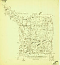 1925 San Marcos 4-a1925 Print · USGSCaldwell and Gonzales counties are captured during the mid-twenties, showcasing a landscape shaped by rural school districts and diverging rail lines. Genealogists can locate family landmarks like Soda Spring, Ivy Siding, and the McNeil No 2 School.
 - 1929 Map of Luling
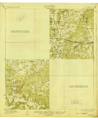 1929 Luling1929 Print · USGSThe Guadalupe and San Marcos river valleys of Central Texas are captured here in the late twenties during a peak era of rail-and-river life. Genealogists can locate family landmarks like Sand Hill Sch, St James Tabernacle, and the old settlement of Belmont.2 unique versions available
End of results
Showing maps 1-2 of 2
Top cities near Harwood
Frequently asked questions
- What are the different types of historical maps available for Harwood?
- What is the oldest map of Harwood?
- Where can I purchase historical maps of Harwood for my home or office?
- Where can I download high-res historical maps of Harwood?
- Are there historical topographic maps available for Harwood?
- Is there historical aerial imagery available for Harwood?
- Where are historical maps of Harwood sourced from?