1960s Maps of Gunter, Texas
Explore 2 historic maps of Gunter from the 1960s. These maps offer a rare glimpse into what life looked like during the 1960s — showing old roads, neighborhoods, homes, and landmarks that have changed or disappeared over time.
Whether you're researching your family's past, planning a metal detecting trip, or studying how Gunter's landscape evolved across the 1960s, these high-resolution maps are a powerful tool for exploring the history of this region.
- Focus on a specific era: All maps on this page are from the 1960s, giving you a focused view of this time period.
- See what’s changed: Compare century-old streets, trails, and buildings to today's modern landscape using overlays and satellite layers.
- Research with precision: Use these maps for genealogy, historical research, land use analysis, or educational projects.
- View, download, or print: Maps are fully viewable online in high resolution, and can be downloaded or printed for your own records.
Start exploring Gunter's history through authentic maps from the 1960s. This is your window into the past.
Gunter, TX maps
(2)- 1961 Map of Gunter, 1963 Print
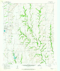 1961 Gunter1963 Print · USGSThis early 1960s survey of the North Texas prairies captures the border between Grayson and Collin counties as the rural landscape began its modern shift. Genealogists and local historians can locate several family burial grounds, including Smallwood Cem and Forbis Cem, and trace the path of the ST LOUIS SAN FRANCISCO railroad.2 unique versions available
 - 1961 Map of Marilee, 1963 Print
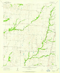 1961 Marilee1963 Print · USGSThe rural borderlands of Grayson, Denton, and Collin counties come into focus in the early sixties as the railroad era meets modern infrastructure. Trace the tracks of the St Louis San Francisco and Texas rail line through Marilee or locate local landmarks like Mt Carmel Ch and Gunter Cem.2 unique versions available
End of results
Showing maps 1-2 of 2
Top cities near Gunter
- McKinney historical maps
- Little Elm historical maps
- Sherman historical maps
- Prosper historical maps
- Anna historical maps
- Melissa historical maps
See more
Top neighborhoods of Gunter
Frequently asked questions
- What are the different types of historical maps available for Gunter?
- What is the oldest map of Gunter?
- Where can I purchase historical maps of Gunter for my home or office?
- Where can I download high-res historical maps of Gunter?
- Are there historical topographic maps available for Gunter?
- Is there historical aerial imagery available for Gunter?
- Where are historical maps of Gunter sourced from?