1900s (20th Century) Maps of Seven L Crossing, Texas
Explore 7 historic maps of Seven L Crossing from the 1900s (20th Century). These maps offer a rare glimpse into what life looked like during the 1900s — showing old roads, neighborhoods, homes, and landmarks that have changed or disappeared over time.
Whether you're researching your family's past, planning a metal detecting trip, or studying how Seven L Crossing's landscape evolved across the 1900s, these high-resolution maps are a powerful tool for exploring the history of this region.
- Focus on a specific era: All maps on this page are from the 1900s, giving you a focused view of this time period.
- See what’s changed: Compare century-old streets, trails, and buildings to today's modern landscape using overlays and satellite layers.
- Research with precision: Use these maps for genealogy, historical research, land use analysis, or educational projects.
- View, download, or print: Maps are fully viewable online in high resolution, and can be downloaded or printed for your own records.
Start exploring Seven L Crossing's history through authentic maps from the 1900s. This is your window into the past.
Seven L Crossing, TX maps
(7)- 1927 Map of Quanah 3-a
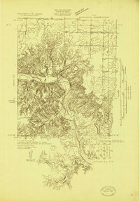 1927 Quanah 3-a1927 Print · USGSThe river breaks of North Texas are captured in the late 1920s as the Pease River divides Hardeman Co and Foard Co. Genealogists and local historians can locate the Forestburg School and trace the winding paths of Groesbeck Creek.
 - 1932 Map of Vivian
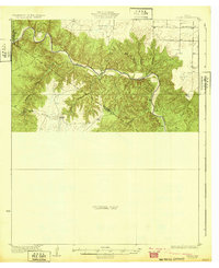 1932 Vivian1932 Print · USGSThe winding valley of the Pease River dominates this north Texas landscape as it appeared in the early thirties. Local history researchers can trace early county lines and rural landmarks like the Forestburg Sch and Teacup Mountain.2 unique versions available
 - 1955 Map of Lawton, 1958 Print
 1955 Lawton1958 Print · USGSSouthwestern Oklahoma and North Texas are shown here in the mid-fifties, dominated by the Wichita Mountains and the vital Red River watershed. Genealogists and historians can trace the foundations of Lawton alongside rural landmarks like Rainy Mountain Church and Pleasant Hill School.5 unique versions available
 - 1960 Map of Teacup Mountain, 1962 Print
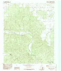
 1960 Teacup Mountain1962 Print · USGSFoard and Hardeman counties are captured in the early sixties as they were shaped by the winding Pease River. Local historians can trace family landmarks and geographic features like Teacup Mountain, Sugarloaf Mountain, and the remote Oil Well site.
 - 1984 Map of Maybell Canyon, 1985 Print
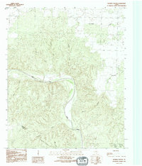
 1984 Maybell Canyon1985 Print · USGSThe Pease River corridor in Hardeman and Foard Counties is shown here as it appeared in the late seventies. Researchers can trace the rugged breaks of Maybell Canyon, the boundaries of Copper Breaks State Park, and several named tributaries like Arkansos Creek.
 - 1986 Map of Vernon
 1986 Vernon1986 Print · USGSNorth Texas and Southern Oklahoma meet along the river in the mid-1980s, revealing a landscape defined by ranching, oil production, and rail transport. Researchers can locate distinct landmarks such as Medicine Mound, the Conley Oil Field, and the community of Punkin Center.
 - 1990 Map of Maybell Canyon, 1995 Print
 1990 Maybell Canyon1995 Print · USGSHardeman and Foard counties are captured here in the early nineties, centered on the deep breaks of the Pease River valley. Topography buffs and researchers can trace the drainages of Maybell Canyon and Wanderers Creek or locate the boundaries of Copper Breaks State Park.
End of results
Showing maps 1-7 of 7
Top cities near Seven L Crossing
Frequently asked questions
- What are the different types of historical maps available for Seven L Crossing?
- What is the oldest map of Seven L Crossing?
- Where can I purchase historical maps of Seven L Crossing for my home or office?
- Where can I download high-res historical maps of Seven L Crossing?
- Are there historical topographic maps available for Seven L Crossing?
- Is there historical aerial imagery available for Seven L Crossing?
- Where are historical maps of Seven L Crossing sourced from?