1990s Maps of Houston, Texas
Explore 27 historic maps of Houston from the 1990s. These maps offer a rare glimpse into what life looked like during the 1990s — showing old roads, neighborhoods, homes, and landmarks that have changed or disappeared over time.
Whether you're researching your family's past, planning a metal detecting trip, or studying how Houston's landscape evolved across the 1990s, these high-resolution maps are a powerful tool for exploring the history of this region.
- Focus on a specific era: All maps on this page are from the 1990s, giving you a focused view of this time period.
- See what’s changed: Compare century-old streets, trails, and buildings to today's modern landscape using overlays and satellite layers.
- Research with precision: Use these maps for genealogy, historical research, land use analysis, or educational projects.
- View, download, or print: Maps are fully viewable online in high resolution, and can be downloaded or printed for your own records.
Start exploring Houston's history through authentic maps from the 1990s. This is your window into the past.
Houston, TX maps
(27)- 1992 Map of Houston
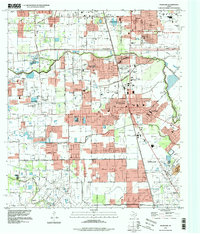
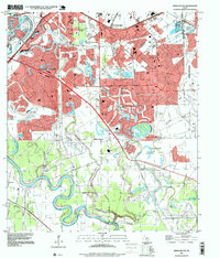
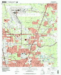
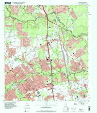
 1992 Houston1992 Print · USGSThe Houston metropolitan area reached its modern sprawl in the early nineties, centered on the Buffalo Bayou and a massive regional rail network. Genealogists and historians can trace the development of satellite cities like Sugar Land and Pasadena, or locate legacy sites like the Humble Oil Field and the NASA Lyndon B Johnson Space Center.
 - 1995 Map of Pearland, 1998 Print
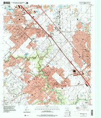
 1995 Pearland1998 Print · USGSThe northern reaches of Brazoria County and the outskirts of Houston are captured here during a mid-nineties period of rapid suburban growth. Researchers can trace the layout of early settlements like Minnetex and Brookside Village alongside several burial grounds including Old Pearland Cem and South Park Cemetery.
 - 1995 Map of Houston Heights, 1998 Print
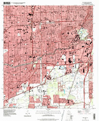
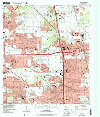
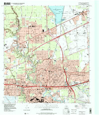
 1995 Houston Heights1998 Print · USGSMid-nineties Houston is captured here during a period of dense urban development and institutional growth. Researchers can trace historic burial sites like Hollywood Cem and Glenwood Cemetery or locate old school sites like Bethune Sch.
 - 1995 Map of Alief, 1998 Print
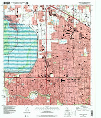
 1995 Alief1998 Print · USGSWestern Houston and the Alief area are seen here during the rapid suburban growth of the mid-nineties. Genealogists and historians can trace local landmarks like Andrau Airpark, the Alief Brethren Cem, and the path of the Missouri Pacific railroad.
 - 1995 Map of Highlands, 1998 Print
 1995 Highlands1998 Print · USGSThe industrial and historical heart of the Texas Gulf Coast comes into focus in the mid-nineties as the suburbs of Houston expand. Researchers can locate family landmarks like San Jacinto Cem, the iconic San Jacinto Monument, and schools such as Harlem Sch.
 - 1995 Map of League City, 1998 Print
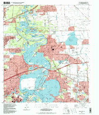
 1995 League City1998 Print · USGSCoastal Harris and Galveston Counties in the mid-nineties show the meeting point of space-age industry and bayside living. Genealogists and historians can trace the growth of League City and find local landmarks like Fairview Cem and the Houston Gulf Airport.
 - 1995 Map of Park Place, 1998 Print
 1995 Park Place1998 Print · USGSSoutheast Houston is seen here during a period of significant urban density in the mid-1990s. Researchers can trace the layout of Texas Southern University, find local family records at Evergreen Cem, and locate the historic Park Place neighborhood.
 - 1995 Map of La Porte, 1999 Print
 1995 La Porte1999 Print · USGSUpper Galveston Bay and the industrial heart of the Texas coast are detailed in this mid-1990s survey. Genealogists and local historians can trace the development of La Porte and Morgans Point alongside the San Jacinto Monument and Wooster Cem.
 - 1995 Map of Cypress, 1999 Print
 1995 Cypress1999 Print · USGSNorthwest Harris County undergoes rapid suburbanization in the mid-nineties as neighborhood grids expand toward the Cypress community. Genealogists and local historians can trace family burial sites like Knigge Cem alongside landmarks like Weiser Air Park and Hot Wells.
 - 1995 Map of Addicks, 1999 Print
 1995 Addicks1999 Print · USGSWest Houston was undergoing intense suburban development in the mid-1990s as residential tracts expanded toward massive flood control works. Researchers can trace the layout of the Addicks community, find the Baker Cem, and see the footprint of Houston West Airport.
 - 1995 Map of Missouri City, 1999 Print
 1995 Missouri City1999 Print · USGSThe Houston suburbs were in the midst of a significant growth phase in the late nineties as residential tracts pushed into the Brazos River bottomlands. Researchers can find old family cemeteries and country churches like Dewalt Cem and St John Ch alongside the rails of the Missouri Pacific.
 - 1995 Map of Bellaire, 1999 Print
 1995 Bellaire1999 Print · USGSSouthwest Houston and Bellaire are shown in the mid-nineties during a period of massive medical and commercial growth. Researchers can trace the development of the Texas Medical Center or locate sites like the Astrodome and The Galleria.
 - 1995 Map of Maedan, 1999 Print
 1995 Maedan1999 Print · USGSSuburban expansion meets the river bottoms of the San Jacinto in the mid-nineties as new residential developments rise near the confluence of major creeks. Researchers can trace family sites at Enloe Cem or locate the community roots of Bordersville and Maedan.
 - 1995 Map of Almeda, 1999 Print
 1995 Almeda1999 Print · USGSThe southern outskirts of Houston and the Fort Bend prairie are shown here during a decade of rapid suburban growth. Genealogists and historians can trace old community landmarks like the Beth Jacob Cem, Mt Corinth Ch, and the rail junction at Arcola.
 - 1995 Map of Tomball, 1999 Print
 1995 Tomball1999 Print · USGSNorth of Houston in the late twentieth century, this area shows the shift from oil fields to suburban residential blocks. Genealogists can locate several historic burial sites, including Pillot Cem and Klein Cem, near the growing settlements of Tomball and Kohrville.
 - 1995 Map of Humble, 1999 Print
 1995 Humble1999 Print · USGSNorthern Houston and the city of Humble are shown during a period of rapid suburban and industrial expansion in the mid-nineties. Researchers can locate numerous local landmarks including Thorne Stadium, Aldine Cem, and the sprawling George Bush Intercontinental Airport.
 - 1995 Map of Settegast, 1999 Print
 1995 Settegast1999 Print · USGSEastern Houston and the Settegast region are captured in the mid-nineties, showing a landscape defined by heavy rail and bayou corridors. Researchers can trace historical footprints at Hollywood Cemetery or explore the massive layout of the Settegast Yards and the busy Turning Basin.
 - 1995 Map of Harmaston, 1999 Print
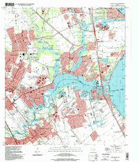
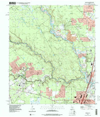
 1995 Harmaston1999 Print · USGSNortheast of Houston in the mid-nineties, suburban growth began pushing into the wetlands and bayous surrounding Lake Houston. Researchers can trace residential development alongside older landmarks like Harrington Cem, the San Jacinto River, and Harmaston.
 - 1995 Map of Friendswood, 1999 Print
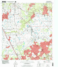
 1995 Friendswood1999 Print · USGSCoastal Texas industry and suburban growth converge south of Houston in the mid-1990s as oil fields meet new residential subdivisions. Genealogists and historians can trace the development of Friendswood and Pearland alongside Whitcomb Cem and the Friendswood Oil Field.
 - 1995 Map of Aldine, 1999 Print
 1995 Aldine1999 Print · USGSAldine and the surrounding Harris County suburbs are shown in the mid-1990s, where energy production and residential growth converge. Researchers can trace family history at Houston National Cemetery or locate local landmarks like the Greenspoint Mall and Aldine High Sch.
 - 1995 Map of Clodine, 1999 Print
 1995 Clodine1999 Print · USGSFort Bend and Harris counties were undergoing rapid suburban change in the mid-nineties as residential developments moved west toward the reservoir. Genealogists can locate family landmarks like Magee Cemetery and Hodges Bend Cem or trace the early footprint of Mission Bend.
 - 1995 Map of Hedwig Village, 1999 Print
 1995 Hedwig Village1999 Print · USGSWestern Houston and the Memorial area thrived in the mid-nineties as major commercial hubs and established residential villages expanded. Genealogists and local historians can trace the development of Hedwig Village and find landmarks like Memorial Oaks Cem or the Spring Branch Ed Center.
 - 1995 Map of Spring, 2000 Print
 1995 Spring2000 Print · USGSThe northern reaches of Harris County are shown in the mid-1990s during a period of rapid suburban growth. Genealogists and local historians can trace family burial sites like Wunsche Cem and Budde Cem or locate the early campus of North Harris County College.
 - 1995 Map of Jacinto City, 2000 Print
 1995 Jacinto City2000 Print · USGSEastern Harris County in the mid-nineties shows a transition from the dense residential grids of Jacinto City to the industrial waterfronts of Jacintoport. Researchers can locate neighborhood landmarks like Cloverleaf Cem and Southern Bible College alongside the expansive Sheldon Reservoir.
 - 1995 Map of Moonshine Hill, 2000 Print
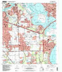
 1995 Moonshine Hill2000 Print · USGSGreater Houston and the San Jacinto forks are captured during a period of significant suburban expansion in the mid-nineties. Researchers can trace the development of Kingwood and Porter, or locate smaller features like Moonshine Hill, Pittsville, and Whiskey Still Pond.
Showing maps 1-25 of 27
Top cities near Houston
- Sugar Land historical maps
- Missouri City historical maps
- Stafford historical maps
- Bellaire historical maps
- South Houston historical maps
- Aldine historical maps
See more
Top neighborhoods of Houston
- Mayfair historical maps
- Hobby historical maps
- Golfcrest historical maps
- Hudson historical maps
- Lakewood Heights historical maps
- Clinton Park historical maps
See more
Frequently asked questions
- What are the different types of historical maps available for Houston?
- What is the oldest map of Houston?
- Where can I purchase historical maps of Houston for my home or office?
- Where can I download high-res historical maps of Houston?
- Are there historical topographic maps available for Houston?
- Is there historical aerial imagery available for Houston?
- Where are historical maps of Houston sourced from?