1960s Maps of Hays, Texas
Explore 4 historic maps of Hays from the 1960s. These maps offer a rare glimpse into what life looked like during the 1960s — showing old roads, neighborhoods, homes, and landmarks that have changed or disappeared over time.
Whether you're researching your family's past, planning a metal detecting trip, or studying how Hays's landscape evolved across the 1960s, these high-resolution maps are a powerful tool for exploring the history of this region.
- Focus on a specific era: All maps on this page are from the 1960s, giving you a focused view of this time period.
- See what’s changed: Compare century-old streets, trails, and buildings to today's modern landscape using overlays and satellite layers.
- Research with precision: Use these maps for genealogy, historical research, land use analysis, or educational projects.
- View, download, or print: Maps are fully viewable online in high resolution, and can be downloaded or printed for your own records.
Start exploring Hays's history through authentic maps from the 1960s. This is your window into the past.
Hays, TX maps
(4)- 1966 Map of Oak Hill, 1969 Print
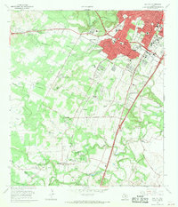 1966 Oak Hill1969 Print · USGSSouthwest Austin was undergoing a transformation in the late sixties as suburban development reached into Travis County. Researchers can trace early family sites and rural landmarks like Kineheonville, Manchaca, and Williamson Creek Cem.2 unique versions available
 - 1968 Map of Signal Hill, 1971 Print
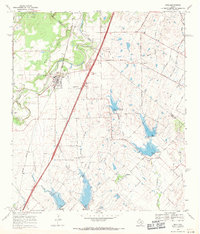
 1968 Signal Hill1971 Print · USGSTexas ranching life and early suburban development converge on the Travis and Hays county line during the late sixties. Researchers can trace family landmarks like Cedar Valley, Oliver Cem, and legacy properties such as Signal Hill Ranch.3 unique versions available
 - 1968 Map of Buda, 1971 Print
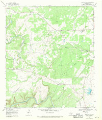
 1968 Buda1971 Print · USGSThe Hays and Travis County borderlands come to life in this late sixties survey of the Buda area. Genealogists and historians can trace family names and early rural centers through sites like Allen Cem, Science Hall, and the Martin Ch.4 unique versions available
 - 1968 Map of Mountain City, 1971 Print
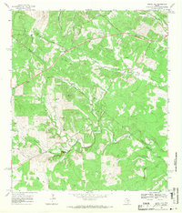
 1968 Mountain City1971 Print · USGSTexas Hill Country ranching life is well-documented here in the late sixties, showing the vast estates and rural outposts south of Austin. Researchers can trace family legacies at Kuykendall Ranch, Ruby Ranch, and the Barton Cem near the banks of Onion Creek.4 unique versions available
End of results
Showing maps 1-4 of 4
Top cities near Hays
- Austin historical maps
- San Marcos historical maps
- Kyle historical maps
- Lakeway historical maps
- Buda historical maps
- Lockhart historical maps
See more
Frequently asked questions
- What are the different types of historical maps available for Hays?
- What is the oldest map of Hays?
- Where can I purchase historical maps of Hays for my home or office?
- Where can I download high-res historical maps of Hays?
- Are there historical topographic maps available for Hays?
- Is there historical aerial imagery available for Hays?
- Where are historical maps of Hays sourced from?