1960s Maps of Niederwald, Texas
Explore 4 historic maps of Niederwald from the 1960s. These maps offer a rare glimpse into what life looked like during the 1960s — showing old roads, neighborhoods, homes, and landmarks that have changed or disappeared over time.
Whether you're researching your family's past, planning a metal detecting trip, or studying how Niederwald's landscape evolved across the 1960s, these high-resolution maps are a powerful tool for exploring the history of this region.
- Focus on a specific era: All maps on this page are from the 1960s, giving you a focused view of this time period.
- See what’s changed: Compare century-old streets, trails, and buildings to today's modern landscape using overlays and satellite layers.
- Research with precision: Use these maps for genealogy, historical research, land use analysis, or educational projects.
- View, download, or print: Maps are fully viewable online in high resolution, and can be downloaded or printed for your own records.
Start exploring Niederwald's history through authentic maps from the 1960s. This is your window into the past.
Niederwald, TX maps
(4)- 1963 Map of Lockhart North, 1966 Print
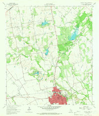 1963 Lockhart North1966 Print · USGSCaldwell County's landscape in the early sixties showcases a growing Lockhart integrated with a sophisticated network of flood control reservoirs and rail lines. Family historians can trace rural roots through Ohlendorf Cem, Polonia Cem, and the Carver High Sch.3 unique versions available
 - 1964 Map of Uhland, 1966 Print
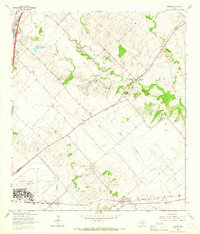 1964 Uhland1966 Print · USGSThe Blackland Prairie of Hays and Caldwell Counties comes into focus during the mid-1960s, a time when small agricultural hubs still dominated the landscape. You can trace family roots through localized sites like Doyle Cem, San Juan Ch, and the rail-side community of Maxwell.3 unique versions available
 - 1968 Map of Buda, 1971 Print
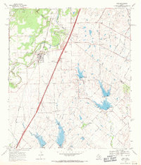 1968 Buda1971 Print · USGSThe Hays and Travis County borderlands come to life in this late sixties survey of the Buda area. Genealogists and historians can trace family names and early rural centers through sites like Allen Cem, Science Hall, and the Martin Ch.4 unique versions available
 - 1968 Map of Creedmoor, 1971 Print
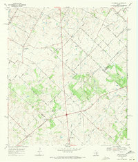 1968 Creedmoor1971 Print · USGSCentral Texas farm country comes into focus in the late sixties as Creedmoor and Niederwald anchor the rural landscape. Trace family roots through local landmarks like Vasquez Cem, Creedmoor Cem, and the Center Union Ch.4 unique versions available
End of results
Showing maps 1-4 of 4
Top cities near Niederwald
- Austin historical maps
- San Marcos historical maps
- Kyle historical maps
- Buda historical maps
- Lockhart historical maps
- Martindale historical maps
See more
Frequently asked questions
- What are the different types of historical maps available for Niederwald?
- What is the oldest map of Niederwald?
- Where can I purchase historical maps of Niederwald for my home or office?
- Where can I download high-res historical maps of Niederwald?
- Are there historical topographic maps available for Niederwald?
- Is there historical aerial imagery available for Niederwald?
- Where are historical maps of Niederwald sourced from?