1960s Maps of Trinidad, Texas
Explore 3 historic maps of Trinidad from the 1960s. These maps offer a rare glimpse into what life looked like during the 1960s — showing old roads, neighborhoods, homes, and landmarks that have changed or disappeared over time.
Whether you're researching your family's past, planning a metal detecting trip, or studying how Trinidad's landscape evolved across the 1960s, these high-resolution maps are a powerful tool for exploring the history of this region.
- Focus on a specific era: All maps on this page are from the 1960s, giving you a focused view of this time period.
- See what’s changed: Compare century-old streets, trails, and buildings to today's modern landscape using overlays and satellite layers.
- Research with precision: Use these maps for genealogy, historical research, land use analysis, or educational projects.
- View, download, or print: Maps are fully viewable online in high resolution, and can be downloaded or printed for your own records.
Start exploring Trinidad's history through authentic maps from the 1960s. This is your window into the past.
Trinidad, TX maps
(3)- 1960 Map of Creslenn Ranch, 1961 Print
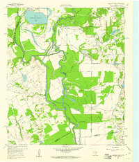 1960 Creslenn Ranch1961 Print · USGSThe Trinity River bottoms and the Cayuga oil country are captured here at the start of the 1960s. Genealogists and local historians can trace the Princeton Cem, the remote Creslenn Ranch, and landmarks like Hall Lake and Trinidad.3 unique versions available
 - 1960 Map of Malakoff, 1961 Print
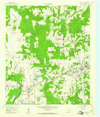 1960 Malakoff1961 Print · USGSThe Trinity River valley in 1960 reveals a landscape of industrial power and small-town growth between Trinidad and Malakoff. Genealogists and historians can trace local landmarks like the St Paul Industrial Sch, Kilman Hospital, and Isaac Cem.4 unique versions available
 - 1961 Map of Kerens, 1962 Print
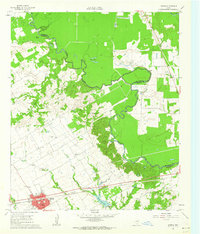 1961 Kerens1962 Print · USGSKerens and the fertile Trinity River bottomlands are captured here in the early sixties, showing a landscape defined by rail, oil, and water. Genealogists and researchers can locate Oak Grove Ch, the Bazette Oil Field, and family-named water features like Singletary Lake.3 unique versions available
End of results
Showing maps 1-3 of 3
Top cities near Trinidad
- Athens historical maps
- Gun Barrel City historical maps
- Mabank historical maps
- Tool historical maps
- Malakoff historical maps
- Kerens historical maps
See more
Frequently asked questions
- What are the different types of historical maps available for Trinidad?
- What is the oldest map of Trinidad?
- Where can I purchase historical maps of Trinidad for my home or office?
- Where can I download high-res historical maps of Trinidad?
- Are there historical topographic maps available for Trinidad?
- Is there historical aerial imagery available for Trinidad?
- Where are historical maps of Trinidad sourced from?